Garland, Kansas
Appearance
Garland, Kansas | |
|---|---|
 | |
| Coordinates: 37°43′54″N 94°37′21″W / 37.73167°N 94.62250°W[1] | |
| Country | United States |
| State | Kansas |
| County | Bourbon |
| Elevation | 853 ft (260 m) |
| Population | |
| • Total | 31 |
| Time zone | UTC-6 (CST) |
| • Summer (DST) | UTC-5 (CDT) |
| ZIP code | 66741 |
| Area code | 620 |
| FIPS code | 20-25900 [1] |
| GNIS ID | 475024 [1] |
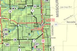
Garland is an unincorporated community in Bourbon County, Kansas, United States.[1] As of the 2020 census, the population of the community and nearby areas was 31.[2] It is located along the Missouri state line 8.5 miles (13.7 km) southeast of Fort Scott.
History
Garland was originally called Memphis. The name was changed to Garland (after a brand of stoves) when the railroad came through in the 1880s.[3]
Geography
Garland is located along the Missouri state line 8.5 miles (13.7 km) southeast of Fort Scott.
Demographics
| Census | Pop. | Note | %± |
|---|---|---|---|
| 2020 | 31 | — | |
| U.S. Decennial Census | |||
For statistical purposes, the United States Census Bureau has defined Garland as a census-designated place (CDP).
Education
The community is served by Fort Scott USD 234 public school district.
References
- ^ a b c d e "Garland, Kansas", Geographic Names Information System, United States Geological Survey, United States Department of the Interior
- ^ a b "Profile of Garland, Kansas (CDP) in 2020". United States Census Bureau. Archived from the original on November 8, 2022. Retrieved November 8, 2022.
- ^ "Many Towns Have Disappeared". The Fort Scott Tribune. Jul 16, 1976. pp. 2C. Retrieved 16 May 2015.
Further reading
External links

