
Grote Knip
Grote Knip
Playa Abou | |
|---|---|
.jpg) Grote Knip | |
 Location in Curaçao | |
| Coordinates: 12°21′06″N 69°09′06″W / 12.35167°N 69.15167°W | |
| Location | Westpunt, Curaçao |
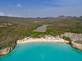
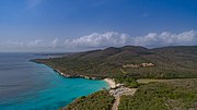
Grote Knip (also called Playa Abou in Papiamento, translation: "Beach in a valley") is a beach on the Caribbean island of Curaçao, located at the western side of the island, between the villages of Westpunt and Lagun.[1] The beach gives way to a small lagune between high rocks. It is freely accessible to the public. The beach is used as a starting point for snorkeling, due to the presence of a coral reef nearby.
Gallery
-
 Grote Knip, Kenepa Grandi beach
 -
 Grote Knip Curaçao
 -
 Aerial Grote Knip Curaçao
.jpg)
.jpg)
.jpg)
References
- ^ "Grote Knip Playa Kenepa Grandi". Vakantie Curacao.nl (in Dutch). Vakantie.
Wikimedia Commons has media related to Grote Knip.
This Curaçao location article is a stub. You can help Wikipedia by expanding it. |