Hawston
Appearance
Hawston | |
|---|---|
| Coordinates: 34°23′S 19°08′E / 34.383°S 19.133°E | |
| Country | South Africa |
| Province | Western Cape |
| District | Overberg |
| Municipality | Overstrand |
| Area | |
| • Total | 4.65 km2 (1.80 sq mi) |
| Population (2011)[1] | |
| • Total | 8,214 |
| • Density | 1,800/km2 (4,600/sq mi) |
| Racial makeup (2011) | |
| • Black African | 1.2% |
| • Coloured | 96.0% |
| • Indian/Asian | 0.2% |
| • White | 0.4% |
| • Other | 2.3% |
| First languages (2011) | |
| • Afrikaans | 95.3% |
| • English | 3.5% |
| • Other | 1.2% |
| Time zone | UTC+2 (SAST) |
| Postal code (street) | 7202 |
| PO box | 7202 |
| Area code | 021 |
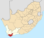
Hawston is a village in the Western Cape, South Africa, It is a fishing village north-east of Mudge Point, 5 km north-west of Onrusrivier and 11 km from Hermanus. It is named after C.R. Haw, a civil commissioner of Caledon.[2]
Located in the Overstrand Local Municipality, about an hour from Cape Town, it is located between Fisherhaven and Vermont, Western Cape, and is close to Hermanus.[3]
References
- ^ a b c d "Main Place Hawston". Census 2011.
- ^ "Dictionary of Southern African Place Names (Public Domain)". Human Science Research Council. p. 201.
- ^ Hawston Archived 2010-06-19 at the Wayback Machine WhaleRock.co.za


