
Hesweiler
Hesweiler | |
|---|---|
 Coat of arms | |
Location of Hesweiler within Cochem-Zell district 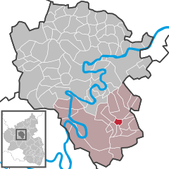 | |
 Hesweiler  Hesweiler | |
| Coordinates: 50°2′40″N 7°16′54″E / 50.04444°N 7.28167°E | |
| Country | Germany |
| State | Rhineland-Palatinate |
| District | Cochem-Zell |
| Municipal assoc. | Zell (Mosel) |
| Government | |
| • Mayor (2019–24) | Manfred Wilhelms[1] |
| Area | |
| • Total | 2.31 km2 (0.89 sq mi) |
| Elevation | 390 m (1,280 ft) |
| Population (2022-12-31)[2] | |
| • Total | 119 |
| • Density | 52/km2 (130/sq mi) |
| Time zone | UTC+01:00 (CET) |
| • Summer (DST) | UTC+02:00 (CEST) |
| Postal codes | 56865 |
| Dialling codes | 06545 |
| Vehicle registration | COC |
Hesweiler is an Ortsgemeinde – a municipality belonging to a Verbandsgemeinde, a kind of collective municipality – in the Cochem-Zell district in Rhineland-Palatinate, Germany. It belongs to the Verbandsgemeinde of Zell, whose seat is in the municipality of Zell an der Mosel.
Geography
The municipality lies in the northern Hunsrück near Bundesstraße 421 and Blankenrath.
History
In 1259, Hesweiler had its first documentary mention. The Counts of Sponheim held the court jurisdiction in the Hasericher Pflege (roughly “Haserich fostering”) until 1788. Beginning in 1794, Hesweiler was under French rule. In 1815, it was assigned to the Kingdom of Prussia at the Congress of Vienna. In 1848, the local chapel, consecrated to Saint Joseph, was built by the master builder Binzen from Zell. Since 1946, Hesweiler has been part of the then newly founded state of Rhineland-Palatinate. Under the Verwaltungsvereinfachungsgesetz (“Administration Simplification Law”) of 18 July 1970, with effect from 7 November 1970, the municipality was grouped into the Verbandsgemeinde of Zell.
Politics
Municipal council
The council is made up of 6 council members, who were elected by majority vote at the municipal election held on 7 June 2009, and the honorary mayor as chairman.[3]
Coat of arms
The municipality's arms might in English heraldic language be described thus: A fess sable charged with a saw argent, the whole between, in chief, argent a cross gules and, in base, chequy of twenty-four argent and gules.
Culture and sightseeing
Buildings
The following are listed buildings or sites in Rhineland-Palatinate’s Directory of Cultural Monuments:
- Catholic Church, Hauptstraße – aisleless church, Rundbogenstil, 1848
- Hauptstraße 18 – Quereinhaus (a combination residential and commercial house divided for these two purposes down the middle, perpendicularly to the street); timber-frame building, partly solid or slated, half-hipped roof, 19th century
- Hauptstraße 30 – Quereinhaus; timber-frame building, partly solid, 18th century[4]
-
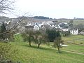 Hesweiler seen from the east
 -
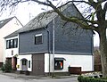 Community centre in the village centre
 -
 Hesweiler Chapel


Economy and infrastructure
Transport
Hesweiler lies within the Verkehrsverbund Rhein-Mosel. Bus route 722 daily offers links to the nearest town, Zell (Mosel), and the nearest railway station, Bullay (DB), on the Moselstrecke (railway line) between Koblenz and Trier.
References
- ^ Direktwahlen 2019, Landkreis Cochem-Zell, Landeswahlleiter Rheinland-Pfalz, accessed 9 August 2021.
- ^ "Bevölkerungsstand 2022, Kreise, Gemeinden, Verbandsgemeinden" (PDF) (in German). Statistisches Landesamt Rheinland-Pfalz. 2023.
- ^ Kommunalwahl Rheinland-Pfalz 2009, Gemeinderat
- ^ Directory of Cultural Monuments in Cochem-Zell district

| International | |
|---|---|
| National | |
This Rhineland-Palatinate location article is a stub. You can help Wikipedia by expanding it. |