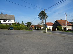
Hřiměždice
Appearance
Hřiměždice | |
|---|---|
 Vestec, a part of Hřiměždice | |
| Coordinates: 49°41′13″N 14°16′30″E / 49.68694°N 14.27500°E | |
| Country | |
| Region | Central Bohemian |
| District | Příbram |
| First mentioned | 1325 |
| Area | |
| • Total | 8.51 km2 (3.29 sq mi) |
| Elevation | 325 m (1,066 ft) |
| Population (2022-01-01)[1] | |
| • Total | 380 |
| • Density | 45/km2 (120/sq mi) |
| Time zone | UTC+1 (CET) |
| • Summer (DST) | UTC+2 (CEST) |
| Postal codes | 262 14, 263 01 |
| Website | www |
Hřiměždice is a municipality and village in Příbram District in the Central Bohemian Region of the Czech Republic. It has about 400 inhabitants. It lies on the shore of Slapy Reservoir.
Administrative parts
Villages of Háje and Vestec are administrative parts of Hřiměždice.
References
Wikimedia Commons has media related to Hřiměždice.


