
File:Atlas Mongolica East.png
Size of this preview: 800 × 571 pixels. Other resolutions: 320 × 228 pixels | 640 × 457 pixels | 1,000 × 714 pixels.
Original file (1,000 × 714 pixels, file size: 355 KB, MIME type: image/png)
| This is a file from the Wikimedia Commons. Information from its description page there is shown below. Commons is a freely licensed media file repository. You can help. |
Summary
| Description |
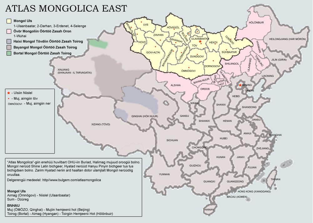
English: Atlas of Eastern Mongols. The map is being in process. Latest version will include Buryatia and Kalmykia; county-level subjects within the PRC. Note that the current version is a draft with some major errors: No Govi-Sümber province of Mongolia and no Wuhai prefecture of Inner Mongolia is present.
The map uses Latin Mongolian. |
| Date | 23 October 2007 (original upload date) |
| Source | Transferred from en.wikipedia to Commons by man77. |
| Author | Dagvadorj at English Wikipedia |
Licensing
| This work has been released into the public domain by its author, Dagvadorj at English Wikipedia. This applies worldwide. In some countries this may not be legally possible; if so: Dagvadorj grants anyone the right to use this work for any purpose, without any conditions, unless such conditions are required by law. |
Original upload log
The original description page was here. All following user names refer to en.wikipedia.
- 2007-10-23 08:30 Dagvadorj 1000×714×8 (363781 bytes) Atlas of Eastern Mongols. The map is being in process. Latest version will include Buryatia and Kalmykia; county-level subjects within the PRC. Note that the current version is a draft with some major errors: No Govi-Sümber province of Mongolia and no Wu
File history
Click on a date/time to view the file as it appeared at that time.
| Date/Time | Thumbnail | Dimensions | User | Comment | |
|---|---|---|---|---|---|
| current | 12:20, 11 April 2008 | | 1,000 × 714 (355 KB) | File Upload Bot (Magnus Manske) | {{BotMoveToCommons|en.wikipedia}} {{Information |Description={{en|Atlas of Eastern Mongols. The map is being in process. Latest version will include Buryatia and Kalmykia; county-level subjects within the PRC. Note that the current version is a draft wit |
File usage
No pages on the English Wikipedia use this file (pages on other projects are not listed).
Global file usage
The following other wikis use this file:
- Usage on el.wikipedia.org
- Usage on es.wikipedia.org
- Usage on fr.wikipedia.org
- Usage on gan.wikipedia.org
- Usage on ja.wikipedia.org
- Usage on ko.wikipedia.org
- Usage on lv.wikipedia.org
- Usage on mk.wikipedia.org
- Usage on mn.wikipedia.org
- Usage on nl.wikipedia.org
- Usage on sr.wikipedia.org
- Usage on vi.wikipedia.org
- Usage on zh.wikipedia.org