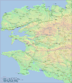
File:Finistère.gif
Appearance

Size of this preview: 526 × 599 pixels. Other resolutions: 211 × 240 pixels | 421 × 480 pixels | 674 × 768 pixels | 899 × 1,024 pixels | 1,500 × 1,709 pixels.
Original file (1,500 × 1,709 pixels, file size: 1.14 MB, MIME type: image/gif)
File history
Click on a date/time to view the file as it appeared at that time.
| Date/Time | Thumbnail | Dimensions | User | Comment | |
|---|---|---|---|---|---|
| current | 20:30, 26 February 2008 |  | 1,500 × 1,709 (1.14 MB) | Sardon | {{Information |Description=Carte du réseau ferroviaire finistérien à son apogée |Source=own work |Date=2008-02-26 |Author=Ludovic Claudel |Permission= |other_versions= }} |
File usage
The following 2 pages use this file:
Global file usage
The following other wikis use this file:
- Usage on fr.wikipedia.org
- Utilisateur:Sardon
- Chemins de fer armoricains
- Chemins de fer départementaux du Finistère
- Catégorie:Ligne ferroviaire dans le Finistère
- Portail:Finistère/Lumière sur…
- Wikipédia:Sélection/Transports
- Wikipédia:Lumière sur/Avril 2009
- Wikipédia:Lumière sur/Chemins de fer départementaux du Finistère
- Wikipédia:Sélection/Entreprises
- Tramway de Brest au Conquet
- Wikipédia:Sélection/Bretagne
- Wikipédia:Sélection/Histoire de Bretagne
- Wikipédia:Sélection/France/Bons articles/E à L
- Usage on www.wikidata.org

