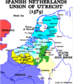
File:Map-1579 Union of Utrecht.png
Appearance

Size of this preview: 523 × 600 pixels. Other resolutions: 209 × 240 pixels | 599 × 687 pixels.
Original file (599 × 687 pixels, file size: 173 KB, MIME type: image/png)
File history
Click on a date/time to view the file as it appeared at that time.
| Date/Time | Thumbnail | Dimensions | User | Comment | |
|---|---|---|---|---|---|
| current | 14:16, 9 January 2005 |  | 599 × 687 (173 KB) | Moyogo | |
| 15:12, 26 December 2004 |  | 599 × 687 (173 KB) | Moyogo | language mistakes | |
| 15:09, 26 December 2004 |  | 599 × 687 (178 KB) | Moyogo | Brussels, Antwerp and Bredao in the Union of Utrecht | |
| 03:50, 26 December 2004 |  | 520 × 596 (147 KB) | Moyogo | Calais -> France | |
| 03:30, 26 December 2004 |  | 527 × 604 (150 KB) | Moyogo | Map of the Union of Utrecht in 1579 | |
| 03:09, 26 December 2004 |  | 527 × 604 (150 KB) | Moyogo | Map of the Union of Utrecht in 1579 |
File usage
The following page uses this file:
Global file usage
The following other wikis use this file:
- Usage on be-tarask.wikipedia.org
- Usage on be.wikipedia.org
- Usage on ca.wikipedia.org
- Usage on cs.wikipedia.org
- Usage on el.wikipedia.org
- Usage on et.wikipedia.org
- Usage on eu.wikipedia.org
- Usage on ko.wikipedia.org
- Usage on pl.wikipedia.org
- Usage on pt.wikipedia.org
- Usage on ro.wikipedia.org
- Usage on rue.wikipedia.org
- Usage on sl.wikipedia.org
- Usage on uk.wikipedia.org
- Usage on www.wikidata.org


