
File:Melbourne railways map.gif
Size of this preview: 548 × 599 pixels. Other resolutions: 219 × 240 pixels | 439 × 480 pixels | 702 × 768 pixels | 936 × 1,024 pixels | 2,126 × 2,325 pixels.
Original file (2,126 × 2,325 pixels, file size: 213 KB, MIME type: image/gif, 0.1 s)
| This is a file from the Wikimedia Commons. Information from its description page there is shown below. Commons is a freely licensed media file repository. You can help. |
Summary
| Description |
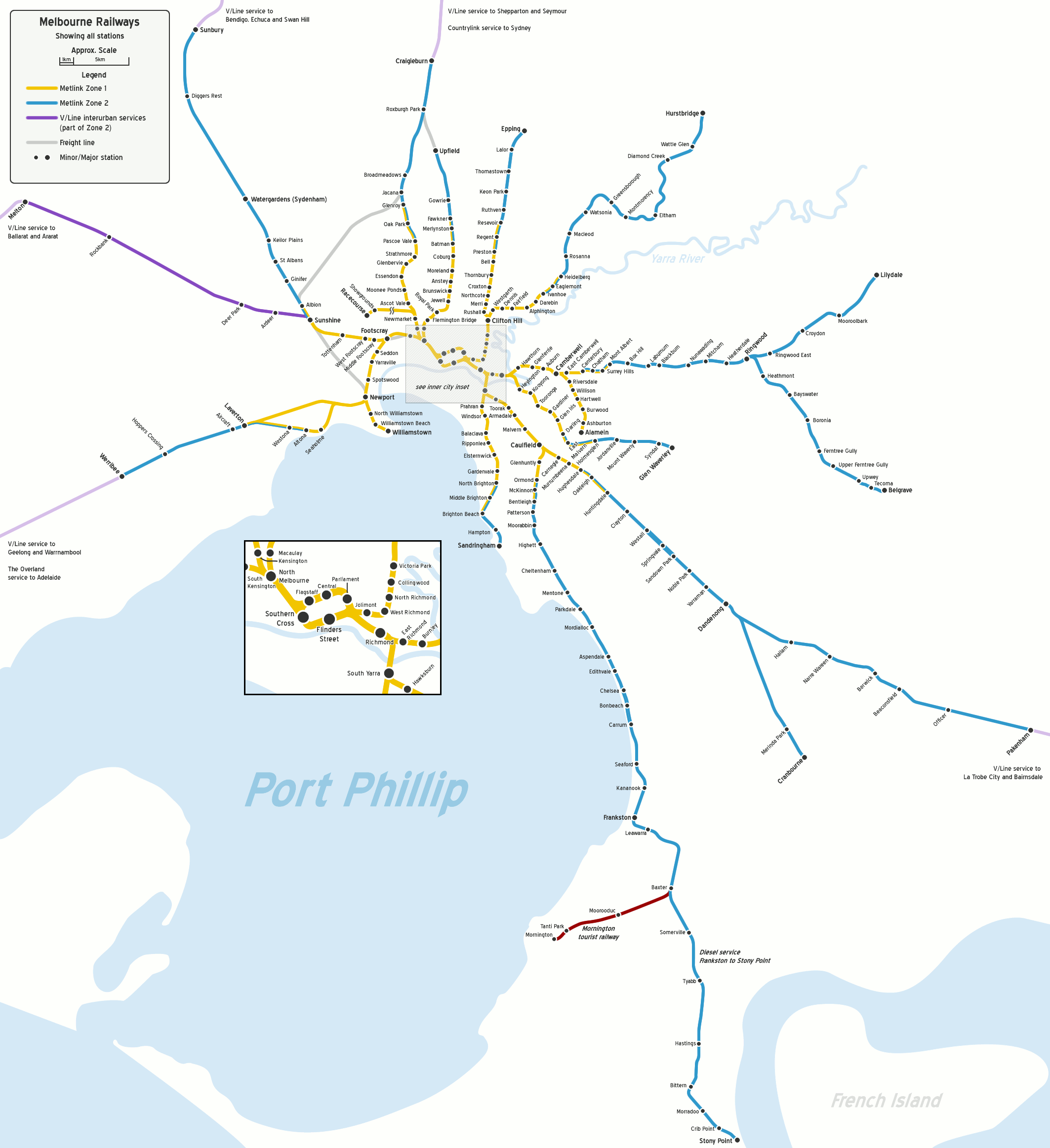
English: Map of Melbourne's railway network, geographically accurate, to approximate scale. Shows all stations. |
| Date | |
| Source | Own work |
| Author | John Shadbolt |
| Other versions | Derivative works of this file: Melbourne RRL.png |

|
This transport map image could be re-created using vector graphics as an SVG file. This has several advantages; see Commons:Media for cleanup for more information. If an SVG form of this image is available, please upload it and afterwards replace this template with
{{vector version available|new image name}}.
It is recommended to name the SVG file “Melbourne railways map.svg”—then the template Vector version available (or Vva) does not need the new image name parameter. |
Licensing
This file is licensed under the Creative Commons Attribution 2.5 Generic license.
- You are free:
- to share – to copy, distribute and transmit the work
- to remix – to adapt the work
- Under the following conditions:
- attribution – You must give appropriate credit, provide a link to the license, and indicate if changes were made. You may do so in any reasonable manner, but not in any way that suggests the licensor endorses you or your use.
Original upload log
Transferred from en.wikipedia to Commons by Oxyman using CommonsHelper.
The original description page was here. All following user names refer to en.wikipedia.
- 2007-10-18 06:33 JohnnoShadbolt 2126×2325× (209777 bytes) {{Information |Description=Map of [[Melbourne|Melbourne's]] railway network, geographically accurate, to approximate scale. Shows all stations. |Source=Own work. |Date=18th October, 2007 |Author=[[User:JohnnoShadbolt|John Shadbolt]] |Permission= |other_ve
- 2007-03-06 04:53 JohnnoShadbolt 2126×2325× (179878 bytes) {{Information |Description=Map of [[Melbourne|Melbourne's]] railway network, geographically accurate, to approximate scale. Shows all stations. |Source=Own work. |Date=31st December, 2006 (updated 6th March, 2007) |Author=[[User:JohnnoShadbolt|John Shadbo
- 2006-12-31 06:46 JohnnoShadbolt 2126×2325× (179845 bytes) {{Information |Description=Map of [[Melbourne|Melbourne's]] railway network, geographically accurate, to approximate scale. Shows all stations. |Source=Own work. |Date=31st December, 2006 |Author=[[User:JohnnoShadbolt|John Shadbolt]] |Permission= |other_v
File history
Click on a date/time to view the file as it appeared at that time.
| Date/Time | Thumbnail | Dimensions | User | Comment | |
|---|---|---|---|---|---|
| current | 02:50, 8 December 2012 | | 2,126 × 2,325 (213 KB) | Jamvanderloeff | try again |
| 02:48, 8 December 2012 |  | 2,126 × 2,325 (213 KB) | Jamvanderloeff | Sunbury line now part of Metro | |
| 01:43, 2 August 2009 |  | 2,126 × 2,325 (205 KB) | File Upload Bot (Magnus Manske) | {{BotMoveToCommons|en.wikipedia|year={{subst:CURRENTYEAR}}|month={{subst:CURRENTMONTHNAME}}|day={{subst:CURRENTDAY}}}} {{Information |Description={{en|Map of Melbourne's railway network, geographically accurate, to approximate scale. Sh |
File usage
The following pages on the English Wikipedia use this file (pages on other projects are not listed):
Global file usage
The following other wikis use this file:
- Usage on es.wikipedia.org
- Usage on fi.wikipedia.org
- Usage on fr.wikipedia.org
- Usage on no.wikipedia.org
- Usage on sv.wikipedia.org
- Usage on test.wikipedia.org
- Usage on uk.wikivoyage.org
- Usage on www.wikidata.org