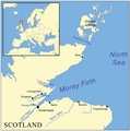
File:Morayfirthmap.png
Appearance

Size of this preview: 597 × 600 pixels. Other resolutions: 239 × 240 pixels | 478 × 480 pixels | 995 × 1,000 pixels.
Original file (995 × 1,000 pixels, file size: 280 KB, MIME type: image/png)
File history
Click on a date/time to view the file as it appeared at that time.
| Date/Time | Thumbnail | Dimensions | User | Comment | |
|---|---|---|---|---|---|
| current | 09:47, 4 July 2012 |  | 995 × 1,000 (280 KB) | Dricherby | sp Dornoch (was "Dornach"). |
| 16:11, 22 May 2007 |  | 995 × 1,000 (317 KB) | Kmusser | fix montenegro boundary | |
| 16:01, 22 May 2007 |  | 995 × 1,000 (317 KB) | Kmusser | {{Information |Description=This is a map of the Moray Firth including a small locator map, based on Digital Chart of the World data. |Source=self-made |Date= May 22, 2007 |Author= User:Kmusser |
File usage
The following page uses this file:
Global file usage
The following other wikis use this file:
- Usage on br.wikipedia.org
- Usage on de.wikipedia.org
- Usage on es.wikipedia.org
- Usage on fi.wikipedia.org
- Usage on fr.wikipedia.org
- Usage on gd.wikipedia.org
- Usage on ia.wikipedia.org
- Usage on it.wikipedia.org
- Usage on ja.wikipedia.org
- Usage on nl.wikipedia.org
- Usage on nn.wikipedia.org
- Usage on no.wikipedia.org
- Usage on pl.wikipedia.org
- Usage on ru.wikipedia.org
- Usage on sco.wikipedia.org
- Usage on vi.wikipedia.org
