
File:OJC diagram.gif

Size of this preview: 391 × 599 pixels. Other resolutions: 156 × 240 pixels | 313 × 480 pixels | 644 × 987 pixels.
Original file (644 × 987 pixels, file size: 44 KB, MIME type: image/gif)
| This is a file from the Wikimedia Commons. Information from its description page there is shown below. Commons is a freely licensed media file repository. You can help. |
Summary
| Description |
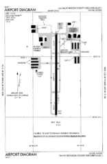
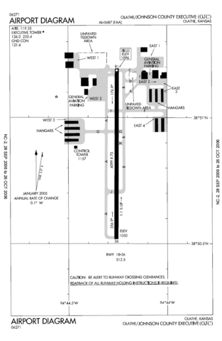
English: FAA diagram for en:Johnson County Executive Airport (OJC), in Olathe, Kansas, United States. Warning: this diagram contains material which is subject to change, do not use for navigation. |
| Date |
|
| Source |
http://naco.faa.gov/d-tpp/0610/05687AD.PDF Note: this URL changes monthly; the airport article should contain a link to the current FAA diagram. |
| Author |
The original uploader was Jameschipmunk at English Wikipedia. |

|
This file has been superseded by KOJC Airport Diagram.svg. It is recommended to use the other file. Please note that deleting superseded images requires consent.
|

|
Licensing
This image or file is a work of a Federal Aviation Administration employee, taken or made as part of that person's official duties. As a work of the U.S. federal government, the image is in the public domain in the United States.
|
 |
Original upload log
The original description page was here. All following user names refer to en.wikipedia.
- 2006-10-17 22:38 Jameschipmunk 644×987×8 (44600 bytes) Airport diagram of Johnson County Executive, in Olathe, Kansas. www.airnav.com/airport/KOJC, http://204.108.4.16/d-tpp/0610/05687AD.PDF {{PD-USGov-FAA}}
File history
Click on a date/time to view the file as it appeared at that time.
| Date/Time | Thumbnail | Dimensions | User | Comment | |
|---|---|---|---|---|---|
| current | 22:32, 5 January 2008 | | 644 × 987 (44 KB) | Meno25 | Higher resolution |
| 22:10, 5 January 2008 |  | 391 × 599 (28 KB) | Meno25 | {{Information |Description={{en|FAA diagram for en:Johnson County Executive Airport (OJC), in Olathe, Kansas, United States. <br/>''Warning: this diagram contains material which is subject to change, do not use for navigation.''<br/> [[:en:Category: |
File usage
No pages on the English Wikipedia use this file (pages on other projects are not listed).
Global file usage
The following other wikis use this file:
- Usage on arz.wikipedia.org
- Usage on ceb.wikipedia.org
- Usage on en.wikivoyage.org
- Usage on fa.wikipedia.org
- Usage on ro.wikipedia.org
- Usage on tg.wikipedia.org
- Usage on ur.wikipedia.org
- Usage on www.wikidata.org