Iron Belt, Wisconsin
Appearance
Iron Belt, Wisconsin | |
|---|---|
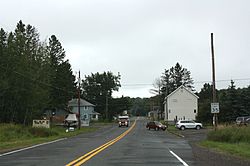
 Looking east at downtown Iron Belt on WIS77 | |
 Location in Iron County and the state of Wisconsin. | |
| Coordinates: 46°24′02″N 90°19′28″W / 46.40056°N 90.32444°W | |
| Country | United States |
| State | Wisconsin |
| County | Iron |
| Town | Knight |
| Area | |
| • Total | 2.451 sq mi (6.35 km2) |
| • Land | 2.451 sq mi (6.35 km2) |
| • Water | 0 sq mi (0 km2) |
| Elevation | 1,555 ft (474 m) |
| Population (2010) | |
| • Total | 173 |
| • Density | 71/sq mi (27/km2) |
| Time zone | UTC-6 (Central (CST)) |
| • Summer (DST) | UTC-5 (CDT) |
| ZIP code | 54536 |
| Area code(s) | 715 & 534 |
| GNIS feature ID | 1566963[1] |

Iron Belt is an unincorporated census-designated place located in Iron County, Wisconsin, United States. Iron Belt is located on Wisconsin Highway 77 southwest of Montreal, in the town of Knight. Iron Belt has a post office with ZIP code 54536.[2] As of the 2010 census, its population was 173.[3]
References

