Kąty Wrocławskie
Kąty Wrocławskie | |
|---|---|
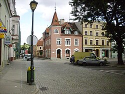
 Fragment of the town square | |
| Country | |
| Voivodeship | Lower Silesian |
| County | Wrocław |
| Gmina | Kąty Wrocławskie |
| Area | |
| • Total | 6.35 km2 (2.45 sq mi) |
| Elevation | 138 m (453 ft) |
| Population (2006) | |
| • Total | 5,418 |
| • Density | 850/km2 (2,200/sq mi) |
| Postal code | 55-080 |
| Website | http://www.katywroclawskie.pl |
Kąty Wrocławskie [ˈkɔntɨ vrɔt͡sˈwafskʲɛ] (German: Kanth) is a town in Wrocław County, Lower Silesian Voivodeship, in south-western Poland. It is the seat of the administrative district (gmina) called Gmina Kąty Wrocławskie. Prior to 1945 it was in Germany. (For more information about the history of the region, see Silesia.)
The town lies approximately 22 kilometres (14 mi) south-west of the regional capital Wrocław. The river Bystrzyca, a tributary of the Oder, flows through the town on the eastern side.
As of 2006, the town has a population of 5,418.
External links
Wikimedia Commons has media related to Kąty Wrocławskie.


