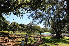
Liliuokalani Park and Gardens

Liliʻuokalani Park and Gardens is a 24.14-acre (97,700 m2) park with Japanese gardens, located on Banyan Drive in Hilo on the island of Hawaiʻi.
The park's site was donated by Queen Liliʻuokalani, and lies southeast of downtown Hilo, on the Waiakea Peninsula in Hilo Bay. Much of the park now consists of Edo-style Japanese gardens, built 1917-1919, and said to be the largest such gardens outside Japan. The gardens contain Waihonu Pond as well as bridges, ponds, pagodas, statues, torii, and a Japanese teahouse.[1]
- Points of interest
- Parks and open spaces
- Transportation
Included in the park is the small island called Moku ola, (also known as Coconut Island), connected to the park by a footbridge. It is a good place for a picnic, and some limited swimming. The name Moku ola literally means "island of life" in the Hawaiian language, since it was the site of an ancient temple dedicated to healing.[2] There is a stone tower on the east side of the island which is the remnant of the old footbridge which was destroyed by a tsunami. From Coconut Island one has a great view of Hilo Bayfront, Downtown Hilo, and the rest of Hilo Bay. To the east, you can see the massive breakwater protecting Hilo Bay. It is located at coordinates 19°43′36″N 155°4′6″W / 19.72667°N 155.06833°W.[3] It is maintained by the County of Hawaii and non-profit Friends of Liliuokalani Gardens.[4]
In 2021, a bronze sculpture by local artist, Henry Bianchini, was relocated from the main garden area to a nearby location in Isle Beach Park.[5][6]
The park is a popular location for public events, exercise, and dog-walking.
Gallery
-
Pagoda and Torii in Liliu'okalani Gardens
-
Banyan Tree and Bamboo at the Gardens
-
View looking across Hilo Bay towards the Hamakua Coast
-
Panoramic view of some of the rock/water paths in Liliu'okalani Park in Hil
-
Sunset over Hilo from Liliu'okalani Park in Hilo
-
Panorama of Liliʻoukalani Park and Gardens in Hilo, Hawaii
-
Hilo Bay and Hilo town from Liliu'okalani Gardens
References
- ^ "Liliʻuokalani Park and Gardens". downtown Hilo Association web site. Archived from the original on 2009-12-17. Retrieved 2013-03-02.
- ^ Lloyd J. Soehren. "lookup of mokuola". Hawaiian Place Names web site. University of Hawaii. Retrieved 2009-10-12.
- ^ "South Hilo map 5". Shoreline access. official Hawaiʻi County web site. Archived from the original on 2011-07-08. Retrieved 2009-10-12.
- ^ "Department of Parks and Recreation". official Hawaiʻi County web site. Archived from the original on 2009-02-13. Retrieved 2009-10-12.
- ^ "'Fisherman' statue relocated in Hilo park". Hawaii Tribune-Herald. 2021-08-05. Retrieved 2022-10-29.
- ^ "VIDEO: Artist Testifies On Sculpture Set For Relocation In Hilo". www.bigislandvideonews.com. Retrieved 2022-10-29.


