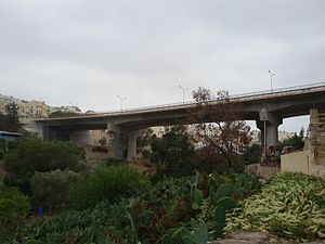
Manwel Dimech Bridge
35°54′58″N 14°29′10.4″E / 35.91611°N 14.486222°E
Manwel Dimech Bridge | |
|---|---|
 East view | |
| Coordinates | 35°54′58″N 14°29′10.4″E / 35.91611°N 14.486222°E |
| Carries | Four lanes |
| Crosses | Wied Għomor |
| Locale | San Ġiljan, Malta |
| Characteristics | |
| Total length | 130 m (426.5 ft) |
| Width | 32 m (105.0 ft) |
| Clearance below | 40 m (131.2 ft) |
| Design life | Modern bridge |
| History | |
| Opened | 18 September 1971 |
| Location | |
 | |
Manwel Dimech Bridge is a beam bridge at St. Julian's, Malta. It is named after Manuel Dimech, and was officially inaugurated on 18 September 1971 by the Minister of Public Works, Lorry Sant. The bridge is approximately 130m long and 32m wide, and spans over Wied Għomor. It is part of Mikiel Anton Vassalli Road (popularly known as Regional Road) just beyond the tunnels on the way to Paceville and St. Andrew's. A commemorative plaque close to the bridge reports that the construction of the bridge, the road and the tunnels were aided by the Chinese government. The tunnels are named after Sun Yat-sen, and the bridge on the other side of the tunnels is named after Ġużè Ellul Mercer. The bridge was thoroughly restored and reinforced in 2008.[1][2][3][4]
References
- ^ "What happened on... October 17". Times of Malta. Retrieved 2020-11-30.
- ^ "What happened on... October 18". Times of Malta. Retrieved 2020-11-30.
- ^ "A Link to the North – Manwel Dimech Bridge - The Malta Independent". www.independent.com.mt. Retrieved 2020-11-30.
- ^ "Manwel Dimech Bridge could reopen next week". Times of Malta. Retrieved 2020-11-30.
