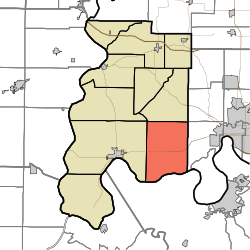
Marrs Township, Posey County, Indiana
Appearance
Marrs Township Posey County | |
|---|---|
 | |
| Coordinates: 37°56′47″N 87°45′21″W / 37.94639°N 87.75583°W | |
| Country | United States |
| State | Indiana |
| County | Posey |
| Government | |
| • Type | Indiana township |
| Area | |
| • Total | 52.12 sq mi (134.98 km2) |
| • Land | 51.54 sq mi (133.5 km2) |
| • Water | 0.57 sq mi (1.48 km2) |
| Elevation | 436 ft (133 m) |
| Population (2000) | |
| • Total | 4,868 |
| • Density | 94.44/sq mi (36.47/km2) |
| FIPS code | 18-47250[2] |
| GNIS feature ID | 453614 |
Marrs Township is one of ten townships in Posey County, Indiana. As of the 2000 census, its population was 4,868.
History
Marrs Township was organized in 1817.[3] The township was named for Samuel R. Marrs, a pioneer settler and afterward county commissioner.[4]
Adjacent Townships
- Indiana
- Posey County
- Black Township (West)
- Lynn Township (Single Point - Northwest)
- Robinson Township (North)
- Vanderburgh County
- German Township (Single Point - Northeast)
- Perry Township (East)
- Posey County
- Kentucky
- Henderson County
- Corydon District (South)
- Henderson County
Unincorporated Places
References
- ^ "US Board on Geographic Names". United States Geological Survey. 2007-10-25. Retrieved 2008-01-31.
- ^ "U.S. Census website". United States Census Bureau. Retrieved 2008-01-31.
- ^ Leffel, John C. (1913). History of Posey County, Indiana. Standard Publishing Company. p. 81.
- ^ History of Posey County, Indiana: from the earliest times to the present. Goodspeed Publishing Co. 1886. p. 311.
External links

