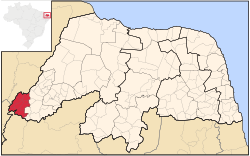
Microregion of Serra de São Miguel
Appearance
Serra de São Miguel | |
|---|---|
 | |
| Country | Brazil |
| State | Rio Grande do Norte |
| Mesoregion | Oeste Potiguar |
Serra de São Miguel is a microregion in the Brazilian state of Rio Grande do Norte.
Municipalities[edit]
The microregion consists of the following municipalities:[1]
- Água Nova
- Coronel João Pessoa
- Doutor Severiano
- Ecnanto
- Luís Gomes
- Major Sales
- Riacho de Santana
- São Miguel
- Venha-Ver
References[edit]
- ^ Instituto Brasileiro de Geografia e Estatística[permanent dead link], territorial division.
6°12′43″S 38°29′49″W / 6.21194°S 38.49694°W
