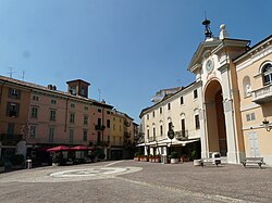
Moncalvo
Moncalvo | |
|---|---|
| Città di Moncalvo | |
 | |
| Coordinates: 45°3′N 8°16′E / 45.050°N 8.267°E | |
| Country | Italy |
| Region | Piedmont |
| Province | Asti (AT) |
| Frazioni | Castellino, Patro, Santa Maria, Gessi, Stazione |
| Government | |
| • Mayor | Aldo Fara |
| Area | |
| • Total | 17.7 km2 (6.8 sq mi) |
| Elevation | 305 m (1,001 ft) |
| Population (31 October 2017)[2] | |
| • Total | 2,967 |
| • Density | 170/km2 (430/sq mi) |
| Demonym | Moncalvini |
| Time zone | UTC+1 (CET) |
| • Summer (DST) | UTC+2 (CEST) |
| Postal code | 14036 |
| Dialing code | 0141 |
| Patron saint | St. Anthony of Padua |
| Saint day | June 13 |
| Website | Official website |
Moncalvo is a village and comune in the Province of Asti in the Italian region Piedmont, located about 45 kilometres (28 mi) east of Turin and about 15 kilometres (9 mi) northeast of Asti on the national road SS 547 which links Asti to Casale Monferrato and Vercelli. Historically it was part of the state of Montferrat and was of particular importance during the early years of the Paleologi period of the marquisate. Its best-known inhabitants were the Baroque painter Guglielmo Caccia and ‘La Bella Rosin’, King Victor Emmanuel II’s favourite mistress and eventually wife.
Moncalvo borders the following municipalities: Alfiano Natta, Castelletto Merli, Cereseto, Grana, Grazzano Badoglio, Ottiglio, Penango, and Ponzano Monferrato.
Main sights
[edit]Churches in the town include:[3]
- Sant'Antonio da Padova, 10th century parish church
- San Francesco d’Assisi. Built in 1272, rebuilt in 1644, now parish church
- San Antonio Abate, built in 1623
- Madonna delle Grazie. Originally an oratory of the 16th century, rebuilt by Magnocavalli (1756-58).
- San Marco - 15th century church adjacent to hospital
- San Rocco, erected im 1600
- San Giovanni Battista - church erected 1960
- Chiesa dell’ Annunciazione (dell’ Ospizio) - near Palazzo Cissello
- San Pietro in Vincoli, in strada Gessi, 18th century
- Santa Croce a Patro - church erected in 16th century
- Santa Caterina d’Alessandria in frazione Castellino - Church erected first in 1584; presently a 19th century reconstruction
- San Giorgio presso Castellino - chapel remains of parish church
- Santa Maria delle Peschiere in frazione Santa Maria - Documented since 1573, rebuilt in 1624, and again 1754
References
[edit]- ^ "Superficie di Comuni Province e Regioni italiane al 9 ottobre 2011". Italian National Institute of Statistics. Retrieved 16 March 2019.
- ^ All demographics and other statistics: Italian statistical institute Istat.
- ^ Monferrato arte, churches of Moncalvo.


