
Mount Tengu
| Mount Tengu | |
|---|---|
| 天狗岳 | |
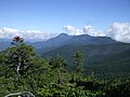
 Mount Tengu from west | |
| Highest point | |
| Elevation | 2,646 m (8,681 ft) |
| Listing | List of mountains and hills of Japan by height |
| Coordinates | 36°01′09″N 138°21′20″E / 36.01917°N 138.35556°E |
| Naming | |
| Language of name | Japanese |
| Pronunciation | [teŋɡudake] |
| Geography | |
| Location | On the border of Chino and Koumi of Nagano in Japan |
| Parent range | Northern Yatsugatake Volcanic Group |
| Geology | |
| Mountain type | Stratovolcano |
Mount Tengu (天狗岳, Tengu-dake) is a 2,646m mountain on the border of Chino and Koumi of Nagano in Japan. This mountain is the highest mountains of Northern Yatsugatake Volcanic Group.
Description
Mount Tengu is a stratovolcano. This mountain is a part of the Yatsugatake-Chūshin Kōgen Quasi-National Park. This mountain is on the list of the 200 famous mountains in Japan. This mountain has two major peaks, Mount Higashi Tengu, and Mount Nishi Tengu.
Climbing route
There are several routes to reach to the top of Mount Tengu. The most popular route is from Karasawa Kosen. It takes about three hours.
Access
Gallery
-
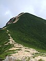
 Mount Tengu from Mount Iō
 -
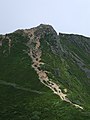
 Mount Nishi Tengu (Left) and Mount Higashi Tengu from Mount Neishi
 -
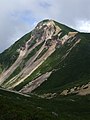
 Mount Nishi Tengu from Mount Higashi Tengu
 -
 Mount Higashi Tengu from Mount Nishi Tengu
 -
 Mount Nishi Tengu from Mount Neishi
 -
 Kuroyuridaira, north of Mount Tengu
 -
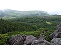 Kuroyuridaira, north of Mount Tengu
 -
 Mount Tateshina from Mount Tengu
 -
 Hida Mountains from Mount Tengu


