Mátraderecske
Appearance
You can help expand this article with text translated from the corresponding article in Hungarian. (February 2018) Click [show] for important translation instructions.
|
Mátraderecske | |
|---|---|
Village (község) | |
 The catholic church of Mátraderecske and the Kékes | |
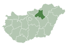
 Location of Heves County in Hungary | |
Location of Mátraderecske in Hungary | |
| Coordinates: 47°56′59″N 20°05′01″E / 47.94972°N 20.08361°E | |
| Country | |
| County | Heves County |
| District | Pétervására District |
| Government | |
| • Mayor | Gábor Forgó |
| Area | |
| • Total | 13.99 km2 (5.40 sq mi) |
| Population (1 Jan. 2015) | |
| • Total | 1,926 |
| • Density | 138.31/km2 (358.2/sq mi) |
| Time zone | UTC+1 (CET) |
| • Summer (DST) | UTC+2 (CEST) |
| Postal code | 3246 |
| Area code | 36 |
| Website | www |
Mátraderecske is a village in Heves County, Northern Hungary Region, Hungary.
Sights

- The castle ruin of Kanázsvár
- The catholic church
- The thermal baths
See also
References
External links
 Media related to Mátraderecske at Wikimedia Commons
47°56′59″N 20°05′01″W / 47.94972°N 20.08361°W


