Nam Tok Sai Yok Noi
Nam Tok Sai Yok Noi
น้ำตกไทรโยคน้อย Tarsoa | |
|---|---|
Small town | |
 Nam Tok Sai Yok Noi railway halt | |
| Coordinates: 14°14′14″N 99°4′2″E / 14.23722°N 99.06722°E | |
| Country | Thailand |
| Province | Kanchanaburi Province |
| District | Sai Yok District |
| Area | |
| • Total | 4.4 km2 (1.7 sq mi) |
| Population (2012)[1] | |
| • Total | 3,675 |
| • Density | 840/km2 (2,200/sq mi) |
| Time zone | UTC+7 (ICT) |
Nam Tok Sai Yok Noi (Template:Lang-th, lit. 'small Sai Yok waterfall') is a small town (thesaban tambon) in Sai Yok District, Kanchanaburi Province, Thailand, along the route of the Death Railway linking Thailand with Burma. It is named after Sai Yok Noi Waterfall of Sai Yok National Park. During World War II, the small town was known as Tarsoa or Tarsau.[2]
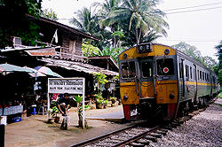
Nam Tok Sai Yok Noi railway halt
After the war most of the railway was dismantled, leaving Nam Tok at the terminus. In 2003 the 1.4 km from Nam Tok station to Nam Tok Sai Yok Noi was reopened for easier access to the nearby Sai Yok waterfall. However, as Sai Yok Noi is a single-platform terminus with no run-round loop, the line is only used by diesel multiple units. The only services to use the extension are trains 909/910 which run an excursion to the waterfall from Bangkok each Saturday and Sunday. All other trains terminate at Nam Tok railway station located about 1 kilometre away.
Work to build a Trans-Asian rail linking eight countries in southeast Asia, which would restore the wartime railway to use, has not yet materialised.
History
The sanitary district (sukhaphiban) was created in 1971.[3] It was upgraded to a township (thesaban tambon) in May 1999, when all of the sanitary districts were upgraded. As of 2012[update], the town had a population of 3,675,[1] and covered an area of 4.4 km2 of subdistrict (tambon) Tha Sao.
Camp Tarsoa
Camp Tarsoa was a large Japanese prisoner of war camp constructed during World War II. It consisted of a transit camp, a work camp and a hospital camp, and was founded on 24 January 1943.[4] The work camp originally contained 400 prisoners, but was enlarged for 800 prisoners.[5] The hospital had a very bad reputation and hardly any medical supplies.[6] There were three large cemeteries near the camp, one of which was for deaths from cholera.[5] The camps closed in April 1944.[4]
Australian prisoners of war veterans erected a memorial at Hellfire Pass, and each year on 25 April, there is a memorial ceremony.[7] Hellfire Pass is located 27 kilometres (17 mi) from Nam Tok.[8]
References
- ^ a b "รายงานสถิติจำนวนประชากร และบ้าน รายจังหวัด รายอำเภอ และรายตำบลณ เดือน ธันวาคม พ.ศ. 2555". Department of Provincial Administration (in Thai). Retrieved 28 January 2022.
Ignore bad certificate warning
- ^ "Tarsau, Thailand. c. October 1945. St Luke's cemetery, containing 613 graves". Australian War Memorial. Retrieved 28 January 2022.
- ^ ประกาศกระทรวงมหาดไทย เรื่อง จัดตั้งสุขาภิบาลน้ำตกไทรโยคน้อย อำเภอไทรโยค จังหวัดกาญจนบุรี (PDF). Royal Gazette (in Thai). 88 (123 ง): 3213–3214. November 16, 1971.
- ^ a b "Tarsao - 130". Japanse Krijgsgevangenkampen (in Dutch). Retrieved 28 January 2022.
- ^ a b "Tarsao Hospital". Far East POW Family. Retrieved 28 January 2022.
- ^ "Tarsau, Tha Sao 125.00km - Thailand". 2/4th Machine Gun Battalion. Retrieved 28 January 2022.
- ^ "25th of April, the ANZAC Day". Hintok River Camp. 17 December 2019. Retrieved 28 January 2022.
- ^ "Section 2b". Far East POW Family. Retrieved 28 January 2022.

