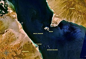
Perim

Perim (Arabic: بريم [Barīm]) is a volcanic island strategically located in the Strait of Mandeb at the southern entrance into the Red Sea off the southwestern coast of Yemen, at 12°39′24″N 43°24′54″E / 12.6566667°N 43.415°E. It has a surface area of 13 square kilometers and rises to an altitude of 65 meters. The island has a natural harbour on its southwestern coast, but there is only scarce vegetation, and the absence of fresh water on the island has always been one of the major difficulties impeding permanent settlement.
Sometimes in the geological past, its eruptions have blocked the Bab el Mandeb and thus the Red Sea evaporated to an empty hot dry salt-floored sink.
The Portuguese came to the island in 1513 but did not stay in the face of Ottoman opposition. France occupied it in 1738. In 1799, the island was briefly occupied by the British East India Company in preparation for the invasion of Egypt. It was reoccupied by the British in 1857 and attached to the colony of Aden, and a lighthouse was built on it. From 1869 onward, the island was used as a coaling station for ships using the Suez Canal. In 1916, Turkish forces attempted to seize the island but were repulsed. British occupation continued until 1967, when the island was handed over to the Democratic People's Republic of Yemen.
References
- The Times, London, 1799, 1857, 1858, 1963
