
Queen Street bus station
Queen Street | |
|---|---|
 | |
| General information | |
| Location | Queen, Elizabeth, Adelaide, George and Albert Street, Brisbane |
| Owned by | TransLink |
| Platforms | 17 |
| Other information | |
| Fare zone | 1 |
Queen Street Bus Station is the Brisbane CBD's primary bus terminus. It is underneath The Myer Centre and Queen Street Mall. It is in Zone 1 of the TransLink integrated public transport system.
Where other Australian cities in earlier decades invested in underground rail, Brisbane, Queensland, in an attempt to clear up city streets, invested in tunnels for its bus system.
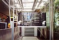
Passengers wait for their buses behind automatic doors in an air-conditioned environment with advanced information displays.
Services
The Queen Street Bus Station serves as the terminus of many routes servicing the South East Busway, Southern and Eastern Suburbs and the Centenary / Indooroopilly / Kenmore corridor.[1]
As of 2009, no Northern Busway services directly connect King George Square busway station with the Queen Street Bus Station. After stopping at King George Square, a number of inbound services bypass the Queen Street Bus Station and stop or terminate at the Cultural Centre on the southern side of the Brisbane River, and vice versa. However, King George Square Busway Station and the Queen Street Bus Station are only a short walking distance apart.
The Station is divided into several platforms originally named after Australian native animals, but now identified by letters and numbers:
| Original platform names |
Platforms | Services (as at 2009) | |
|---|---|---|---|
| Kangaroo and Platypus | → | A1 – A10 | Southern and Eastern Suburbs, South-East Busway |
| Koala | → | B1 – B5 | Centenary / Indooroopilly / Kenmore Corridor |
| Crocodile | → | C1 – C2 | Mt Gravatt and Holland Park services, South-East Busway |
Access
The station has a portal for buses traffic to enter and leave at the northern end of Victoria Bridge, to connect to the Cultural Centre busway station.
The former entry/exit portal (on Albert Street, facing King George Square), from the Queen Street Bus Station, was converted into a tunnel so that the station could be connected to King George Square busway station, which was built (2006–2007) in the lower two levels of the King George Square Car Park.
Photos
-
 Stairwell entrance from Queen Street Mall to
platform A (previously known as the Kangaroo and Platypus platforms) -
 Stairwell entrance from Queen Street Mall to
platform B (previously known as the Koala platform)

