Saint-Vincent, Aosta Valley
Saint-Vincent | |
|---|---|
| Comune di Saint-Vincent Commune de Saint-Vincent | |
| Country | Italy |
| Region | Aosta Valley |
| Province | none |
| Frazioni | Amay, Bacon, Biandin, Biègne, Biéton, Boriolaz, Capard, Chadel, Champcillien, Champdevignes, Cillian, Cisseyaz, Clapéaz, Clapeon, Cretamianaz, Crotache, Crovion, Dizeillle, Écrivin, Favret, Feilley, Fromy, Gléréyaz, Grand-Rhun, Grun, Jacques, Joux, La-Fet, La-Tour-Rosset, Lenty, Lerinon, Maison-Neuve, Marc, Moron, Moulins, Nuarsaz, Orioux, Pallud, Perellaz, Perrière, Petit-Rhun, Piané, Piémartin, Pioule, Pradiran, Renard, Romillod, Ronc-Damon, Ronc-Desot, Salirod, Tensod, Torrent-Sec, Tous, Tréan, Valmignane, Valpellane, Valyre |
| Area | |
| • Total | 20 km2 (8 sq mi) |
| Elevation | 550 m (1,800 ft) |
| Population (31 December 2006)[2] | |
| • Total | 4,846 |
| • Density | 240/km2 (630/sq mi) |
| Demonym | Sabins |
| Time zone | UTC+1 (CET) |
| • Summer (DST) | UTC+2 (CEST) |
| Postal code | 11027 |
| Dialing code | 0166 |
| Patron saint | Vincent of Saragossa |
| Saint day | 22 January |
| Website | Official website |
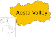
Saint-Vincent is a town and comune in the Aosta Valley region of north-western Italy. Saint-Vincent, elevation 575 metres (1,886 ft), is a popular summer holiday resort with mineral springs (recommended for liver and stomach disorders).
Geography
The town is bounded by Ayas, Brusson, Châtillon, Emarèse and Montjovet.
Notes and references
- ^ "Superficie di Comuni Province e Regioni italiane al 9 ottobre 2011". Italian National Institute of Statistics. Retrieved 16 March 2019.
- ^ "Popolazione Residente al 1° Gennaio 2018". Italian National Institute of Statistics. Retrieved 16 March 2019.


