San Mateo District, Huarochirí
San Mateo | |
|---|---|
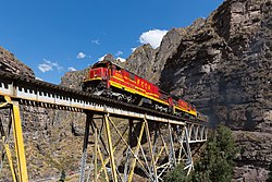
 FCCA (Ferrocarril Central Andino) nrs. 1008 and 1009, two GE C30-7, are crossing a steel bridge between Rio Blanco and San Mateo | |
| Country | |
| Region | Lima |
| Province | Huarochirí |
| Capital | San Mateo |
| Government | |
| • Mayor | Luis Eduardo Rincon Franco (2019-2022) |
| Area | |
| • Total | 425.6 km2 (164.3 sq mi) |
| Elevation | 3,149 m (10,331 ft) |
| Population (2017) | |
| • Total | 4,245 |
| • Density | 10.0/km2 (26/sq mi) |
| Time zone | UTC-5 (PET) |
| UBIGEO | 150722 |
San Mateo District is one of thirty-two districts of the Huarochirí Province, located in the Department of Lima in Peru.[1] It was one of eleven districts that formed the Huarochirí Province after it was created by decree on August 4, 1821, during the Protectorate of San Martín.
Geography[edit]
The La Viuda and the Paryaqaqa or Waruchiri mountain ranges traverse the district. Some of the highest mountains of the district are listed below:[2]
- Allqa Allqa
- Chinchiqucha
- Chunta
- Kunkus Yantaq
- Llipina
- Mankan
- Ñuñu
- Paqcha
- Pachanqutu
- Paka
- Qullqayuq
- Quri
- Sarayuq
- Shiraq
- Suyruqucha
- Tata Qayqu
- Uqhu
- Uqsha Wallqa
- Utush Mikhunan
- Wamanripa
- Waskha
- Yana Qaqa
- Yana Yana
- Yuraq Anka (Junín-Lima)
- Yuraq Anka (Lima)
- Yawriq
See also[edit]
References[edit]
- ^ (in Spanish) Instituto Nacional de Estadística e Informática. Banco de Información Distrital Archived 2008-04-23 at the Wayback Machine. Retrieved April 11, 2008.
- ^ escale.minedu.gob.pe - UGEL map of the Huarochirí Province (Lima Region)
11°45′31″S 76°18′00″W / 11.7586°S 76.3000°W
