Jump to content

Santana do São Francisco

Coordinates: 10°17′27″S 36°36′28″W / 10.29083°S 36.60778°W / -10.29083; -36.60778
From Wikipedia, the free encyclopedia

This is an old revision of this page, as edited by Dewritech (talk | contribs) at 16:23, 13 July 2021 (top: clean up, typo(s) fixed: km² → km<sup>2</sup>). The present address (URL) is a permanent link to this revision, which may differ significantly from the current revision.

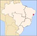
10°17′27″S 36°36′28″W / 10.29083°S 36.60778°W / -10.29083; -36.60778 Santana do São Francisco is a municipality located in the Brazilian state of Sergipe. Its population was 7,844 (2020)[1] and its area is 46 km2.[2]

References

  1. ^ "IBGE 2020". Retrieved 26 January 2021.
  2. ^ IBGE - [1]