Sarayacu District
Appearance
Sarayacu
Sarayaku | |
|---|---|
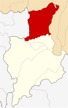
 Location of Sarayacu in the Ucayali Province | |
| Country | |
| Region | Loreto |
| Province | Ucayali |
| Founded | January 2, 1857 |
| Capital | Dos de Mayo |
| Area | |
| • Total | 6,303.17 km2 (2,433.67 sq mi) |
| Elevation | 125 m (410 ft) |
| Population | |
| • Total | 14,712 |
| • Density | 2.3/km2 (6.0/sq mi) |
| Time zone | UTC-5 (PET) |
| UBIGEO | 160605 |
Sarayacu District is one of six districts of the Ucayali Province in Peru.[1]
References
- ^ (in Spanish) Instituto Nacional de Estadística e Informática. Banco de Información Distrital Archived 2008-04-23 at the Wayback Machine. Retrieved April 11, 2008.
6°21′57″S 75°49′38″W / 6.3659°S 75.8272°W
