Seaside Park (Ventura)
Seaside Park is the traditional name of an event venue located at 10 West Harbor Boulevard in Ventura, California. The 62-acre site (25 ha) is the home of the Ventura County Fair.[1] The beach front site, just downcoast of the mouth of the Ventura River, is adjacent to Surfers' Point, known for its point break that produces distinctive waves. E.P. and Orpha Foster envisioned a miniature Golden Gate Park since John McLaren, the designer of that park, was a family friend. They donated the original 65 acres to the County of Ventura, adding another 14 acres later. They wanted a beautiful gateway to Ventura, where families could walk and picnic, play tennis, and enjoy family outings.[2]
The site is now owned by the State of California and is managed by 31st District Agricultural Association, a state special-purpose district in the Division of Fairs and Expositions of the California Department of Food and Agriculture. The Fair Board’s role is to set and approve policies for the organization. Members of the Board of Directors are appointed by the governor of California. They organize the annual Ventura County Fair and run the Derby Club, the live via satellite horse racing off-track wagering facility.[3][4]
Events and activities
Trade shows, concerts and other events are held throughout the year.[3] Babe Ruth Field occupied the area where the large parking lot sits[5] and served as the home of the Ventura Braves, Ventura Yankees and Ventura Oilers professional baseball teams.[6] Although the original race track and grandstand are long gone,[7] the Ventura Raceway is hosted at the fairground when the fair is not in season.
The Omer Rains Bike Trail, connecting the San Buenaventura State Beach downcoast and Emma Wood State Beach upcoast, wraps around the fairgrounds along the beach and river levee.[8] The path is on the Pacific Coast Bicycle Route and also serves as an access point for California Coastal Trail.[9] In 2011, the path was moved inland as part of a managed retreat project, a first of its kind in California. Initially fair officials wanted a buried sea wall to protect the bike path that had been damaged since it was built two decades ago. Surfers fiercely objected, fearing that this would destroy the point break near the Ventura River that generates the distinctive waves at the adjacent city park named Surfers' Point at Seaside Park.[10] Environmentalists projected reduced habitat and increased erosion rates on nearby beaches by the altered wave patterns.[11][12]
History
Miniature Railway

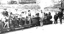
Around 1901, John J. Coit installed and operated a miniature railway in Seaside Park, probably with the unusual gauge of 14½ inch (368 mm). The locomotive, which had been designed by himself, was of the camelback type. After a short period of time he relocated some of the equipment to the Long Beach and Asbury Park Railway.
References
- ^ U.S. Geological Survey Geographic Names Information System: Ventura County Fairgrounds
- ^ Mildred Ranger Schofield, A BRIEF HISTORY OF EUGENE P. FOSTER appended to HISTORY OF THE VENTURA COUNTY PARKS DEPARTMENT
- ^ a b Ventura County Fairgrounds Official Website
- ^ Mosk, Matthew (October 19, 1993) "Fairground Hopes off-Track Betting Is More Addictive Than Smoking : Recreation: Gamblers at Watch and Wager halls may find cigarettes no longer welcome after a board vote today." Los Angeles Times
- ^ U.S. Geological Survey Geographic Names Information System: Babe Ruth Field
- ^ Pastore, Eric and Wendy "DigitalBallparks.com Ventura" Accessed 20 November 2013
- ^ "History of Ventura County Fair & Seaside Park" The Fillmore Gazette 2009 August 5
- ^ "Biking in California State Parks" California Department of Parks and Recreation website. Accessed 10 January 2014
- ^ California Coastal Trail Hiker's Guide: Ventura County Section 4 Map. Accessed 26 January 2014
- ^ Barboza, Tony (January 16, 2011) "In Ventura, a retreat in the face of a rising sea" Ventura County Star
- ^ Downing, Jim; Blumberg, Louis; Hallstein, Eric (2014), "Case study 5: Surfers Point Managed Retreat", written at California Program, Reducing Climate Risks with Natural Infrastructure (PDF), San Francisco: The Nature Conservancy, p. 16, retrieved 9 November 2014
- ^ Davis, Gail (September 12, 2000). "Rock Delivery Shores Up Surfers Point". Los Angeles Times.
