Sirok
Appearance
Sirok | |
|---|---|
Village | |
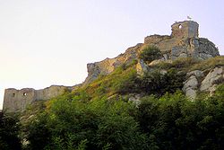
 Sirok Castle ruins | |
| Coordinates: 47°55′52″N 20°11′45″E / 47.93111°N 20.19583°E | |
| Country | Hungary |
| Region | Northern Hungary |
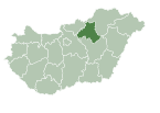
| County | Heves |
| District | Pétervására |
| Area | |
| • Total | 63.39 km2 (24.48 sq mi) |
| Population (1 January 2023)[1] | |
| • Total | 1,629 |
| • Density | 26/km2 (67/sq mi) |
| Time zone | UTC+1 (CET) |
| • Summer (DST) | UTC+2 (CEST) |
| Postal code | 3332 |
| Area code | (+36) 36 |
| Website | www |

Sirok is a historic village (population 2,100) in Heves county in Hungary, situated near Eger in Mátra mountains. Today it is most known for its 13th-century castle ruins.
Etymology
The name comes from the Slavic širokъ—wide like Široka Planina, Široký Důl and many other similar Slavic names.[2][3]
References
- ^ Detailed Gazetteer of Hungary. 30 October 2023 https://www.ksh.hu/apps/hntr.telepules?p_lang=EN&p_id=08527. Retrieved 5 November 2023.
{{cite web}}: Missing or empty|title=(help) - ^ Kiss, Lajos (1978). Földrajzi nevek etimológiai szótára (in Hungarian). Budapest: Akadémiai. p. 574.
- ^ Stanislav, Ján (2004). Slovenský juh v stredoveku II (in Slovak). Slovenské literárne centrum. p. 434. ISBN 80-88878-89-6.


