
Stair, East Ayrshire

The hamlet of Stair in Scotland nestles at the bottom of a glen beside the River Ayr at the north-west border of the 5,376 acre (22;km²) parish of Stair where the River Ayr is joined by Glenstang Burn in what is now known as East Ayrshire.
In the year 1450 William de Dalrymple acquired the lands of Stair-Montgomery and built Stair House. Once part of the District of Kyle, a historic sub-region of Ayrshire, the parish of Stair was created in 1653 at the request of James Dalrymple, 1st Viscount Stair who arranged for the severance of a part of Ochiltree to form a new parish.
Other places of interest in the parish of Stair are Stair brig built in 1745 and Stair Church first built in 1706 and replaced with the existing structure in 1864. Dalmore House (180-81) stood overlooking the River Ayr until destroyed by fire in 1969.
Views in Stair
-
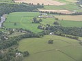 Stair and Stair House Farm
 -
 Stair church
 -
 Stair Bridge over the River Ayr
 -
 The Stair Inn
 -
 Cottages at Milton Mill


See also
- Trabboch
- Barnweill Church
- Dalmore House and Estate
- James Dalrymple, 1st Viscount of Stair (1619–1695), Scottish lawyer and politician
- John Dalrymple, 1st Earl of Stair (1648–1707), son of the previous
- John Dalrymple, 2nd Earl of Stair (1673–1747), son of the previous
- Loch of Stair
- Loch of Trabboch
Bibliography
- Barber, Derek (2000). Steps through Stair. Stair Parish Church.
External links
References
55°28′51″N 4°28′13″W / 55.4807°N 4.4704°W