
Staré

Staré is a village and municipality in Michalovce District in the Kosice Region of eastern Slovakia.
History
In historical records the village was first mentioned in 1221.
Geography
The village lies at an altitude of 107 metres and covers an area of 6.234 km². The municipality has a population of about 700 people. The name was taken from gróf Sztáray. [1]
See also
Gallery
-
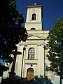 Church of the Assumption of the Virgin Mary, est. 1842 (July 2006)
 -
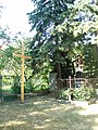 Statue of John of Nepomuk in Staré
 -
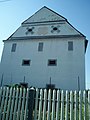
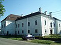 Manor house in Staré, est. early 1600s (July 2006)
 -
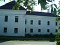 Manor house in Staré, est. early 1600s (July 2006)
 -
 Manor house in Staré, est. early 1600s (July 2006)
 -
 Village granary in Neo-Classical style, est. 1804 (July 2006)
 -
 Village granary in Neo-Classical style, est. 1804 (July 2006)
 -
 Village granary in Neo-Classical style, est. 1804 (July 2006)
_church_(summer)_02.jpg)
_statue_of_St_John_of_Nepomuk_(summer).jpg)
_manor_house_(summer)_05.jpg)
_manor_house_(summer)_03.jpg)
_manor_house_(summer)_01.jpg)
_village_granary_(est._1804,_summer)_01.jpg)
_village_granary_(est._1804,_summer)_03.jpg)
_village_granary_(est._1804,_summer)_02.jpg)
_village_granary_(est._1904,_summer)_01.jpg)
References
External links
Wikimedia Commons has media related to Staré.
- http://www.statistics.sk/mosmis/eng/run.html
- http://www.stare.sk
- http://www.obecstare.wz.cz
- https://web.archive.org/web/20080110184734/http://www.farnost-stare.sk/
48°52′N 21°52′E / 48.867°N 21.867°E
This Michalovce District geography article is a stub. You can help Wikipedia by expanding it. |