Thanbyuzayat
Thanbyuzayat
သံဖြူဇရပ် ဍုၚ်ဇြပ်ဗု | |
|---|---|
Town | |
 | |
| Coordinates: 15°58′N 97°44′E / 15.967°N 97.733°E | |
| Country | |
| Division | |
| District | Mawlamyine District |
| Township | Thanbyuzayat Township |
| Population (2005) | |
| • Religions | Buddhism |
| Time zone | UTC+6.30 (MST) |
Thanbyuzayat[3] (Template:Lang-my; Template:Lang-mnw, lit. 'Tin Shelter'"[4]) is a town in the Mon State of south-eastern Myanmar. It is the administrative center for Thanbyuzayat Township. Thanbyuzayat is about 64 kilometres (40 mi) south of Mawlamyine (Moulmein) and 24 kilometres (15 mi) south-east of Kyaikkami (Amherst) and Setse beach.[4]
History
The name of the town gets its name from a white tin zayat located in the town centre. The interjunction that tin zayat located was once a rest place for travellers, and the tin zayat was constructed in 1874 by a Mon lady called Mi Gee Yut. During WWII, Thanbyuzayat was just a large village within Kyaikkami township, and later gained town status.
Camp Thanbyuzayat
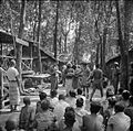
During World War II, Thanbyuzayat was the western terminus of the notorious Death Railway (Siam–Burma Railway) linking up with the pre-war coastal railway between Ye and Rangoon. Thanbyuzayat was also the site of a Japanese prisoner of war camp for the prisoners who worked on building the railway,[5] The first prisoners arrived in June 1942. 13,000 prisoners passed through the camp of which at least 6,000 were Australian and 4,300 Dutch prisoners of war. From Thanbyuzayat, the prisoners were moved to work camps on the railway line. The camp was abandoned on 22 June 1943 due to continuous allied bombardment[6] which killed 12 prisoners.[7]
The Death Railway Museum has been established at the western terminus of the railway.[8] In the Thanbyuzayat War Cemetery, 3,626 Allied servicemen (mostly Australian, British and Dutch)[9] are buried.[10] All prisoners who died on the Burma side have been re-buried at Thanbyuzayat except for the Americans who have been repatriated.[9]
Places of interest
- Thanbyuzayat War Cemetery
- Death Railway Museum
- Setse beach
- Setse Agar jelly production farms
- Pa-nga salt farms[11]
- Pa-nga Ngapi production village
- Kyaik Kohgrain Pagoda
- Hot springs (originally built for WWII Japanese officers)[12]
- Kyaikkhami resort town
- Kyeik Ne' Pagoda Welgalaung Village
Gallery
-
A Japanese labour camp at Thanbyuzayat in WWII
-
The very first locomotive used on the Death Railway
-
The start point of Death Railway Line
-
Thanbyuzayat Prisoners-of-war Cemetery
-
Cenotaph for Asian workers and Allied POWs, built by Japanese
-
Death Railway Museum
-
Abandoned section of Death Railway in Thanbyuzayat
-
Town centre
-
A tombstone of Allied soldier
-
Repatriation of the prisoners at Setse beach after WWII
See also
Notes
- ^ Thanbyuxayat (Variant) at GEOnet Names Server, United States National Geospatial-Intelligence Agency
- ^ Thanbyuzat (Variant) at GEOnet Names Server, United States National Geospatial-Intelligence Agency
- ^ Thanbyuzayat (Approved) at GEOnet Names Server, United States National Geospatial-Intelligence Agency
- ^ a b Reid, Robert and Grosberg, Michael (2005) Myanmar (Burma) (9th edition) Lonely Planet Publications, Footscray, Victoria, Australia, page 159, ISBN 1-74059-695-1
- ^ Rivett, Rohan Deakin (1950) "Chapter XIX: Thanbyuzayat Base Camp" Behind bamboo : an inside story of the Japanese prison camps Angus and Robertson, London, OCLC 13509214
- ^ "Thanbyuzayat – 415 (0)". Japanse Krijgsgevangenkampen (in Dutch). Retrieved 29 January 2022.
- ^ "Thanbyuzayat". Far East POW family. Retrieved 29 January 2022.
- ^ "Death Railway Museum". Lonely Planet. Retrieved 29 January 2022.
- ^ a b "Thanbyuzayat War Cemetery". Commonwealth War Graves Commission. Retrieved 29 January 2022.
- ^ Taylor, William (1971) With the Cambridgeshires at Singapore Trevor Allen Bevis, March, England, pages 89-91, ISBN 0-901680-01-X
- ^ 王晓夏. "Farmers work in salt beds in Myanmar - Xinhua | English.news.cn". www.xinhuanet.com. Archived from the original on March 20, 2019. Retrieved 2019-09-24.
- ^ Kean, Thomas (29 May 2018). "Tracing the Japanese occupation in Thanbyuzayat". Frontier Myanmar. Retrieved 2019-09-24.
External links
- "Thanbyuzayat Map – Satellite Images of Thanbyuzayat" Maplandia World Gazetteer


