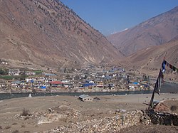
Thuli Bheri River
Appearance
| Thuli Bheri River | |
|---|---|
 | |
 | |
| Location | |
| Country | Nepal |
| Basin features | |
| River system | Karnali River |
Thuli Bheri River, a tributary of Bheri River which in turn is the tributary of the Karnali River. It starts in the Chharka region of Dolpa District where it is known as the Bhargung Khola (river).[1][2][3][4][5][6]
See also
[edit]References
[edit]- ^ "Thuli Bheri – a dream and its reality". Tales adventures from a fairy with a kayak. 8 December 2013. Retrieved 10 January 2019.
- ^ "Solo Down the Thuli Bheri - Kayak Session Magazine". kayaksession.com (in French). Retrieved 10 January 2019.
- ^ "Aftershock – Kayaking the Thuli Bheri River, Nepal". Sidetracked. 10 August 2015. Retrieved 10 January 2019.
- ^ "Thuli Bheri". liquidlore.com. Retrieved 10 January 2019.
- ^ www.nepalriverrunner.com, Nepal River Runner. "Thuli Bheri Cata-kayak Expedition – 14 Days | Nepal River Runner". nepalriverrunner.com. Retrieved 10 January 2019.
- ^ "Mission Thule Bheri - An Epic Self-Support Kayaking Trip in Nepal". Wet Planet Whitewater. 10 February 2015. Retrieved 10 January 2019.
28°41′31″N 82°16′42″E / 28.6920°N 82.2784°E
