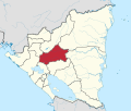
Tuma-La Dalia
Appearance
This article needs additional citations for verification. (January 2021) |
El Tuma-La Dalia | |
|---|---|
Municipality | |
| Coordinates: 13°08′N 85°44′W / 13.133°N 85.733°W | |
| Country | |
| Department | Matagalpa |
| Area | |
| • Municipality | 252 sq mi (652 km2) |
| Population (2021 estimate)[1] | |
| • Municipality | 78,457 |
| • Density | 310/sq mi (120/km2) |
| • Urban | 13,117 |
El Tuma-La Dalia is a municipality in the Matagalpa department of Nicaragua.
References
- ^ Citypopulation.de Population of departments and municipalities in Nicaragua
13°4′N 85°45′W / 13.067°N 85.750°W


