Zağalar
Appearance
Zağalar | |
|---|---|
| Coordinates: 40°01′02.2″N 46°21′24.9″E / 40.017278°N 46.356917°E | |
| Country | |
| District | Kalbajar |
| Elevation | 1,779 m (5,837 ft) |
| Population (2015)[1] | |
| • Total | 8 |
| Time zone | UTC+4 (AZT) |
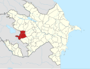
Zağalar (Zaghalar) is a village in the Kalbajar District of Azerbaijan.[2][3]
History
The village was located in the Armenian-occupied territories surrounding Nagorno-Karabakh, coming under the control of ethnic Armenian forces during the First Nagorno-Karabakh War in the early 1990s. It subsequently became part of the Martakert Province of the breakaway Republic of Artsakh, referred to as Andzavner (Armenian: Անձավներ). It was returned to Azerbaijan as part of the 2020 Nagorno-Karabakh ceasefire agreement.
References
- ^ Hakob Ghahramanyan. "Directory of socio-economic characteristics of NKR administrative-territorial units (2015)".
- ^ Azərbaycan Respublikasının Dövlət Statistika Komitəsi (2019). "İnzibati ərazi bölgüsü təsnifatı" (PDF) (in Azerbaijani). stat.gov.az. Archived from the original (PDF) on 2020-04-16. Retrieved 2020-04-16.
- ^ Təhməzov 2013, "Kəlbəcər. Ensiklopedik məlumatlar", Azerbaijan National Academy of Sciences, Baku, ISBN 978-9952-453-11-9, Retrieved on 2021-02-13.


