
Wikipedia:Graphics Lab/Map workshop/Archive/May 2012
Stale[edit]
War in Somalia map[edit]
-
 Current situation of the War in Somalia

Article(s): War in Somalia (2009–present)
Request: Clean up and make SVG to make it easier for users to edit. DrewMek (talk) 17:26, 26 February 2012 (UTC)
Graphist opinion(s): This map is still being actively maintained, I'd suggest contacting the author for changes. Kmusser (talk) 13:52, 29 February 2012 (UTC)
- Sorry, I realise I didn't really state my reason for requesting here: basically, as far as I can tell, the original, and up until a short while ago, only, user updating the map has been inactive for several months. A few users have come forward stating that they would be able to frequently update the map if it was an SVG, but only one has stated that he has the ability and tools to convert the PNG to an SVG without losing quality, and the process he described seemed, to me, heavily time consuming, given the detail of the map (namely, involving tracing over the lines and reinserting the text; I think he also expressed that finding time for it might be an issue). I am wondering if the users here have a better way of doing it, hence the request (and if not, sorry for wasting time). Thanks!--DrewMek (talk) 19:43, 29 February 2012 (UTC)
Oil fields map and distribution[edit]
-
 Oil producing countries map: not accurate enough

Article(s): Oil field
Request:: Although there is allready one image made of oil producing countries, there does not seem to be a map made of known oil fields around the world (see map http://quakeinfo.ucsd.edu/~gabi/sio15/energy/supps/globalmap-oil.jpg ) . In addition, it would be useful to indicate the pipelines connected to it, aswell as maritime shipping routes used to transport the (crude) oil (see http://www.vzg.ru/prod/prod01.jpg ) Should be quite useful for improving info on oil dependance KVDP (talk) 09:52, 2 March 2012 (UTC)
Graphist opinion(s):
List of terrorist incidents 2011[edit]
Article(s): List of armed conflicts and attacks, January - June 2011, List of armed conflicts and attacks, July - December 2011
Request: Could we have a map for the number of incidentsin each country for each page (or for 2011 combined) per other articles? With a code of X-Y (oper number of attacks in each country) for darker shades, etc? Lihaas (talk) 15:10, 3 March 2012 (UTC)
Graphist opinion(s):
List of Chief Ministers in India[edit]
-
Current map
Article(s): List of Chief Ministers in India and others, apparently
Request: Will need updating in a few hours and ill get back here with hat needs to change. In the maeantime please remove "major" from coalitions and just leave coalition.
- UP (blue) is Samajwadi Party (SP) (same colour should suffice, just different name), goa is now brown and Uttaranchal is light greenLihaas (talk) 08:08, 6 March 2012 (UTC)
Graphist opinion(s):
Map of the German Reich[edit]
-
 German Reich during World War II
 -
 Blank map (1938–1939)


Article(s): Nazi Germany
Request: Could someone draw an SVG map of the German Reich during WWII using the blank map as a base, please many thanks. TRAJAN 117 (talk) TRAJAN 117 (talk) 10:12, 7 March 2012 (UTC)
Graphist opinion(s):
Three Rebellions in Shouchun[edit]
-
1st Rebellion in Shouchun (Wang Ling's)
-
2nd Rebellion in Shouchun (Guanqiu Jian and Wen Qin's)
-
3rd Rebellion in Shouchun (Zhuge Dan's Rebellion)
Article(s): Guanqiu Jian and Wen Qin's Rebellion, Zhuge Dan's Rebellion, Wang Ling's Rebellion
Request: Pulled from google maps and saved on Paint.net I need you to get 3 images of JUST the map. Each map needs to be for one rebellion. I need just the terrain (no roads, labels, lines,etc). Then I need each rebellion to have the movements and etc. shown on the map... --Eric - Contact me please. I prefer conversations started on my talk page if the subject is changed 19:51, 30 March 2012 (UTC)
Graphist opinion(s):
Resolved[edit]
France Asia relations.jpg[edit]
-

-
 my PNG version - with overseas territories coloured


Article(s): France-Asia relations
Request: Please improve the quality of this image and color in French Guiana; possibly also dots for French islands Liam987(talk) 15:49, 20 May 2012 (UTC)
Graphist opinion(s): Nobody else seems to be doing anything around here, so I've had a go. -- Peter Talk page 16:18, 20 May 2012 (UTC)
Hyderabad State Map[edit]
-
 The State in 1903
 -
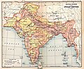 The State in 1909
 -
 2nd map of Hyderabad in 1909


Article(s): Hyderabad State
Request: Using the the maps, make a map which could be presented in the article's infobox. --Monareal (talk) 12:35, 12 April 2012 (UTC)
![]() Done:
Done:
.svg)
Interactive version:http://sharemap.org/public/Hyderabad
Created with:ShareMap
--Jkan997 (talk) 09:40, 25 April 2012 (UTC)
Lazica Map[edit]
-

-

-
 SVG version


Article: Lazica
Request: Redraw first image to SVG format as it is in the second image using the colours it has in the second image. GeorgianJorjadze (talk) 13:43, 11 April 2012 (UTC)
Graphist opinion(s): ![]() Done - ArnoldPlaton (talk) 12:53, 12 April 2012 (UTC)
Done - ArnoldPlaton (talk) 12:53, 12 April 2012 (UTC)
- Thank you. It looks great. Can you please if you have time to do the same with this picture as well and turn it in SVG with same colours and format? GeorgianJorjadze (talk) 15:50, 12 April 2012 (UTC)
- I did them at the same time - ArnoldPlaton (talk) 16:14, 12 April 2012 (UTC)
- Thank you so much for your work. I much appreciate it. May I ask you for some other maps? And can you change on the Diaeuhi map the name Kholka to Colchis? Thanks again. GeorgianJorjadze (talk) 16:20, 12 April 2012 (UTC)
- Done. If you want other maps, post them here, in the workshop. I won't promise to do them but I'll see what I can do. - ArnoldPlaton (talk) 16:56, 12 April 2012 (UTC)
- Thank you so much again. Your images are brilliant. GeorgianJorjadze (talk) 17:07, 12 April 2012 (UTC)
- I'm using stuff already found on Wikipedia. Not that big a deal - ArnoldPlaton (talk) 17:11, 12 April 2012 (UTC)
- I just posted the new request so if you will have time any time soon I'd appreciate your brilliant work. Regards. GeorgianJorjadze (talk) 17:42, 12 April 2012 (UTC)
- I'm using stuff already found on Wikipedia. Not that big a deal - ArnoldPlaton (talk) 17:11, 12 April 2012 (UTC)
- Thank you so much again. Your images are brilliant. GeorgianJorjadze (talk) 17:07, 12 April 2012 (UTC)
- Done. If you want other maps, post them here, in the workshop. I won't promise to do them but I'll see what I can do. - ArnoldPlaton (talk) 16:56, 12 April 2012 (UTC)
- Thank you so much for your work. I much appreciate it. May I ask you for some other maps? And can you change on the Diaeuhi map the name Kholka to Colchis? Thanks again. GeorgianJorjadze (talk) 16:20, 12 April 2012 (UTC)
- I did them at the same time - ArnoldPlaton (talk) 16:14, 12 April 2012 (UTC)
- Thank you. It looks great. Can you please if you have time to do the same with this picture as well and turn it in SVG with same colours and format? GeorgianJorjadze (talk) 15:50, 12 April 2012 (UTC)
Kingdom of Tao-Klarjeti[edit]
-

-

-
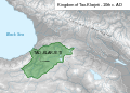 Done
Done


Article(s): Tao-Klarjeti
Request: Redraw the first image into the format of SVG like the second image has, giving it the red colour as it has in the first image. The first image lacks the land till the Black Sea coast so it should also include the Black Sea coast from the border where Kingdom of Tao-Klarjeti begins in red colour. Please do not include anything but only Kingdom of Tao-Klarjeti name and it's capital Artanuji. Only these two names should be written. Please just include the Kingdom of Tao-Klarjeti on the map without rest of the places like in the south some Kaschiten Emirate. And please also write Black Sea on the place of Schwarzes Meer. GeorgianJorjadze (talk) 17:41, 12 April 2012 (UTC)
Graphist opinion(s): ![]() Done I'm not sure I understood your directions. I kept the red part plus the small orange part towards the coast. Is that what you meant? Also, you should put the new map in the relevant articles - ArnoldPlaton (talk) 19:42, 20 April 2012 (UTC)
Done I'm not sure I understood your directions. I kept the red part plus the small orange part towards the coast. Is that what you meant? Also, you should put the new map in the relevant articles - ArnoldPlaton (talk) 19:42, 20 April 2012 (UTC)
- Thanks a lot. Brilliant work. Thanks a lot again. GeorgianJorjadze (talk) 19:49, 20 April 2012 (UTC)
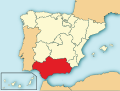
Fixing inset in Andalusia locator map[edit]
-
 Starting image
 -
 This could be the basis for the new inset
 -
 Here is the PNG version I hacked together, but SVG would be preferable


Article(s): Template:Location map Spain Andalusia
Request: Can someone make a new version of this image with an inset that is basically just Spain (rather than also trying to show where in Europe Spain is)? At a normal article scale (see Pedro Muñoz Seca Municipal Theater e.g.), the current inset map is basically useless--readers can't see clearly where in Spain Andalusia is located. Thanks! Calliopejen1 (talk) 03:31, 14 April 2012 (UTC)
- Added additional map that may be useful. Calliopejen1 (talk) 13:55, 17 April 2012 (UTC)
Graphist opinion(s): ![]() Done, but I had to leave the Canaries in the inset as I couldn't figure out how to remove their shadow. Hope it's okay, CMD (talk) 03:29, 18 April 2012 (UTC)
Done, but I had to leave the Canaries in the inset as I couldn't figure out how to remove their shadow. Hope it's okay, CMD (talk) 03:29, 18 April 2012 (UTC)
- It was reverted without comment, but the file is there in the picture history. I suggest you discuss it with the reverter. CMD (talk) 09:56, 19 April 2012 (UTC)
Thanks! I may just upload it as a different image entirely. If anyone else could figure out to remove the Canary Islands, that would be much better. Right now the map is inaccurate because those islands are off the coast of Africa, not near Spain. I was poking around and couldn't figure out how to remove the shadow either, at least without removing the shadow for the whole inset.... Calliopejen1 (talk) 14:36, 19 April 2012 (UTC)
Kingdom of Kartli and Kakheti[edit]
-
-
-
 New File


Article(s): Kartl-Kakheti
Request:
- Please redraw the first image into the format of SVG as it is in the second image.
- Please just write on the map only Kingdom of Kartli and Kakheti with its two capitals Tbilisi and Telavi.
- Please do not include on the map anything but only Kingdom of Kartli and Kakheti.
- Please do not include on the map its neighboring kingdoms or principalities, northern or southern neighbors.
- Please also mention the Black Sea.
Thank you. GeorgianJorjadze (talk) 12:00, 21 April 2012 (UTC)
Graphist opinion(s): ![]() Done. I got the filename a bit wrong, but the rest I hope is ok - ArnoldPlaton (talk) 17:28, 21 April 2012 (UTC)
Done. I got the filename a bit wrong, but the rest I hope is ok - ArnoldPlaton (talk) 17:28, 21 April 2012 (UTC)
- Thank you so much for your help. Your maps are gorgeous and brilliant. Thanks a lot. As for the filename it's all right. If it's possible to change it would be also great but anyways map itself is perfect. GeorgianJorjadze (talk) 17:38, 21 April 2012 (UTC)
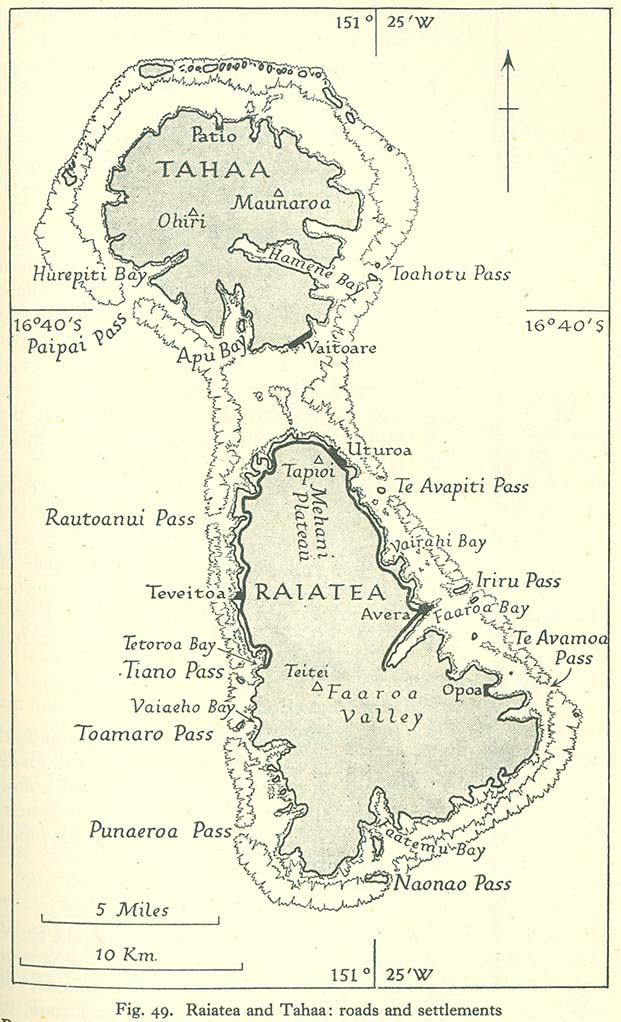
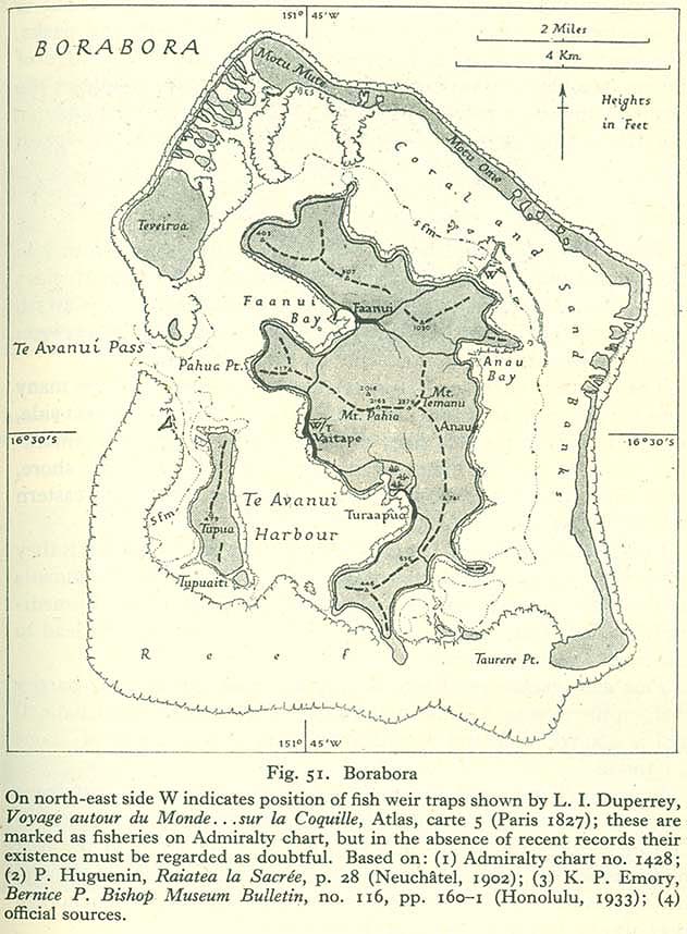
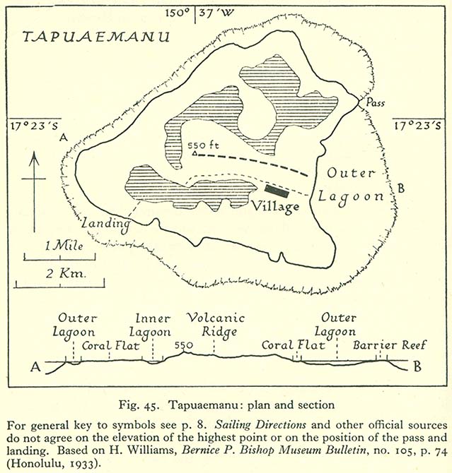
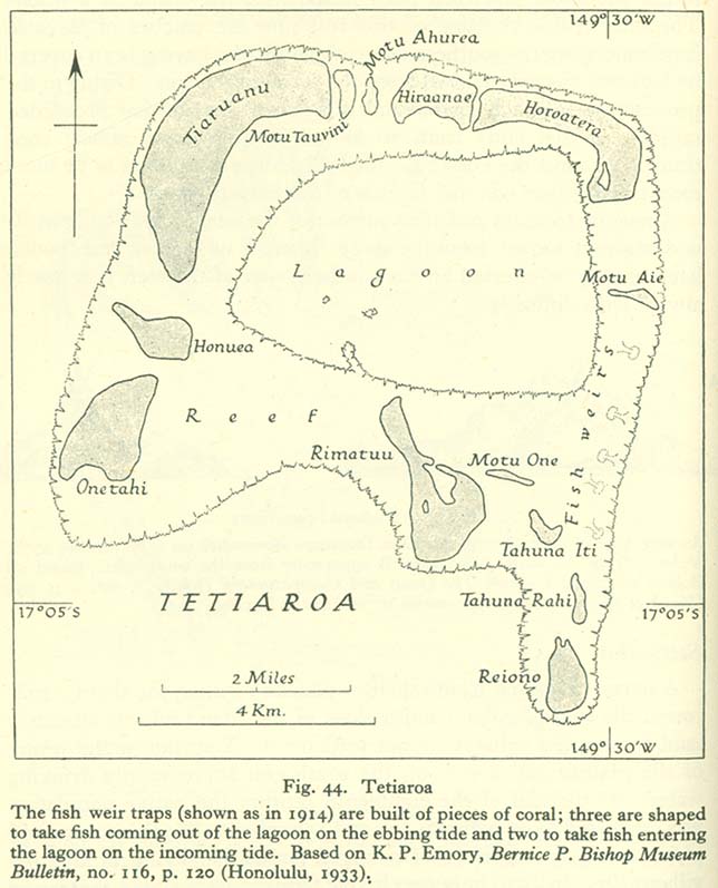
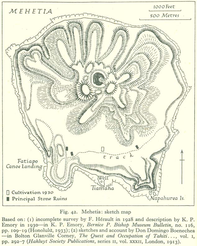
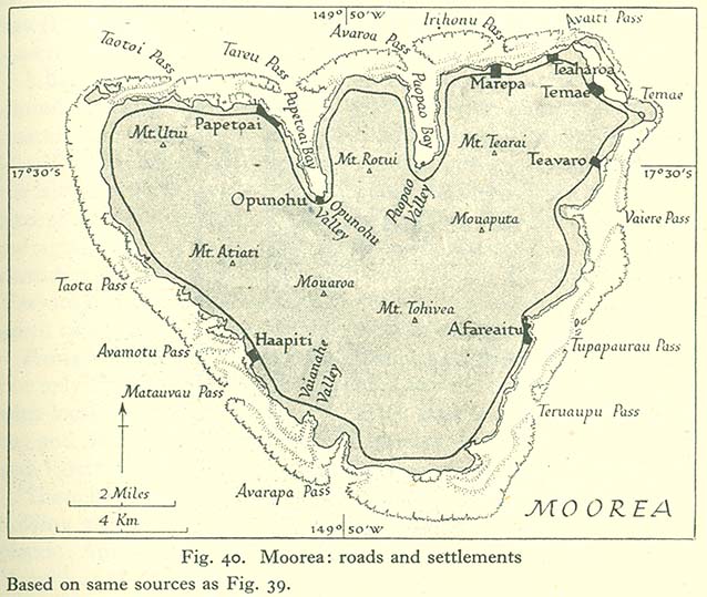
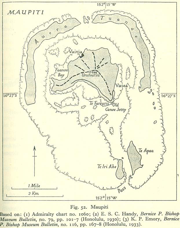
Map of Society Islands from Manuae to Mehetia[edit]
-
 replicate this with all islands from Manuae to Mehetia
 -
 Like this except with more detail
_topographic_map-fr.svg)

Article(s): Society Islands, Windward Islands, Mehetia, Tahiti, Tetiaroa, Moorea, Maiao, Leeward Islands, Huahine, Raiatea, Tahaa, Bora Bora, Tupai, Maupiti, Maupihaa, Motu One (Society Islands), Manuae (Society Islands)
Request: Is there anyway to replicate this but add the outlying islands of Motu One, Manuae, and Mapihaa and sea in between plus the rest of the Society Islands including Tahiti, Maiao, Moorea, Mehetia, and Tetiaroa? It would be a very long map but we can scroll for that. And it will have to have a really high resolution, too. Exact distances and longitude and latitude positioning would be good too... KAVEBEAR (talk) 23:31, 24 April 2012 (UTC)
Graphist opinion(s):
![]() Request taken by Keithpickering (talk). Feasible, if scrolling is OK, but expect it to be huge. Also, expect no relief on the low atolls as they are very flat, although the higher volcanic islands will show relief OK. This will be a jpeg.
Request taken by Keithpickering (talk). Feasible, if scrolling is OK, but expect it to be huge. Also, expect no relief on the low atolls as they are very flat, although the higher volcanic islands will show relief OK. This will be a jpeg.
Also, regarding the level of detail, I can include all the stuff in the Isles Sous Le Vent map, but I don't have a comparably detailed source for the Isles du Vent. That leaves the map rather lopsided in terms of detail. I suggest instead including just the largest town on each island (which is easy to find on e.g. Google Earth) and leaving out names of mountain peaks, airports, and smaller towns. Or if you can provide me with a comparable source for detail in the Isles du Vent, that would work too. Keithpickering (talk) 03:44, 26 April 2012 (UTC)
- The Leeward Islands? Isn't the first version already detailed enough? Which ones are you talking about? Do you mean the Windward Islands to the east?--KAVEBEAR (talk) 03:59, 26 April 2012 (UTC)
- more exact spacing between islands
- Tahiti
- Moorea
- Maiao
- Tetiaroa
- more details of Maupiti
- more details of Bora Bora
- more details of Raiatea and Tahaa
- false more details of Huahine
- another one of Moorea
- Raiatea and Tahaa again
- Bora Bora again
- Huahine again
- Tapuaemanu another name for Maiao
- Tetiaroa again
- Mehetia
- Moorea again
- Maupiti again
- some Maupiti towns and place names
- these are good and detailed but you can read them
- Tahiti
- Tetiaroa
- Moorea
- Huahine
- Raiatea and Tahaa
- Bora Bora
- Maupiti
Yes, I was referring specifically to Tahiti and Moorea. The references you provided will do fine, thanks. Keithpickering (talk) 18:34, 26 April 2012 (UTC)
-
 Version 2: larger scale, topography, bathymetry

Still a lot of work to do, but take a look at the above rough version, and see if this is about what you had in mind for size and scale, and level of detail. Going to a larger scale allows more detail at the cost of more scrolling; going smaller puts more on the page but loses detail. Once we have the basics settled, I will add bathymetry, topograpy, and shading. Also let me know if you have issues with fonts or font sizes. Keithpickering (talk) 21:40, 29 April 2012 (UTC)
- Is this the size that the final version would be like? It's a great map but the islands are too small to make out especially when you include so many town names around it. --KAVEBEAR (talk) 00:11, 1 May 2012 (UTC)
OK, I've enlarged the scale which helps with island placenames, added airports, bathymetry, and topography. A word about the odd topography in Tahiti. This is usually pretty straightforward, but Tahiti turns out to be a very difficult case. Topography and shading is done using a Digital Elevation Model (DEM) of which several exist on the web. Mostly what I use is SRTM, which is a radar map of the globe taken by the space shuttle using side looking airborne radar. SRTM has a known limitation in that it has data dropouts where terrain is very steep. This includes interior portions of Tahiti. So I went to another DEM, called ASTER which was taken from satellite using infrared. But ASTER also has a known limitation, in that it sometimes cannot tell the difference between cloud and ground. In the case of Tahiti, there are always cumulus clouds over the island in the daytime, so ASTER shows some interior areas as higher than Everest (not good). As a final backstop I went to the GEBCO DEM, which has no data dropouts in Tahiti, but which is much lower resolution (30 arcsec rather than 3 arcsec for SRTM and 1 arcsec for ASTER). What you see here is SRTM where available, ASTER where STRM has dropouts, if ASTER is less than 1200 meters; and GEBCO otherwise. There are some odd artifacts from this procedure in the middle of Tahiti which I will correct "by hand" if everything else looks good. Keithpickering (talk) 17:40, 5 May 2012 (UTC)
- I guess this will have to do, but can the water be a lighter shade of blue like File:Leeward Islands (Society Islands) topographic map-fr.svg. Can you cut one new one especially for the Windward Islands and make another one without topography for future use as political maps for some of the former kingdoms of the islands.--KAVEBEAR (talk) 02:46, 8 May 2012 (UTC)
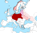
Correction of country locations in Decolonization - World Maps[edit]
-
 Decolonization Map in 1945
 -
 Decolonization Map Today


Article(s): United Nations Trusteeship Council, Self-determination
Request: Please review and correct the location of country names, a good number of which are in the wrong geographic position. In the 1945 map, this includes Bolivia, Chile, Argentina, Ecuador, Dominican Republic, Venezuela, Colombia. Also the Pacific Ocean and Indian Ocean labels are currently placed in the Atlantic Ocean. In some cases the country names are a long way from their proper location. There are also a number of incorrect locations of country and ocean labels in the Decolonization Map Today. Robert Pollard (talk) 17:58, 17 May 2012 (UTC)
Graphist opinion(s):
![]() Done: I converted the text in both SVG images to an approved font (dejaVu sans). The PNG images auto-reformatted, and are displaying correctly. 25or6to4 (talk) 22:19, 21 May 2012 (UTC)
Done: I converted the text in both SVG images to an approved font (dejaVu sans). The PNG images auto-reformatted, and are displaying correctly. 25or6to4 (talk) 22:19, 21 May 2012 (UTC)
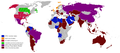
Change color for a single map[edit]
-
 Map of the world with countries highlighted by the number of soldiers

Article(s): List of countries by number of soldiers
Request: While the large majority of major lakes are white, Lake Ladoga is somehow the same color as the rest of Russia; please make it white like the rest. Nyttend (talk) 12:36, 26 April 2012 (UTC)
Graphist opinion(s):
![]() Done-- Orionist ★ talk 06:23, 25 May 2012 (UTC)
Done-- Orionist ★ talk 06:23, 25 May 2012 (UTC)
LTE launched in Russia[edit]

Article(s): LTE (telecommunication)
Request: On 10 may 2012 LTE is commercially launched in Moscow by Scartel inc. marketed Yota. Commercial service in other cities of Russia started even earlier. Time to paint biggest part of the map red. Varnav (talk) 06:25, 14 May 2012 (UTC)
Graphist opinion(s):
![]() Done and updated the whole map with new data. Cheers!-- Orionist ★ talk 02:23, 25 May 2012 (UTC)
Done and updated the whole map with new data. Cheers!-- Orionist ★ talk 02:23, 25 May 2012 (UTC)
Adding Eritrea to the map of Denmark[edit]
-
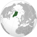 Kingdom of Denmark (orthographic projection)
.svg)
Article(s): Denmark
Request: Back in January, Orionist answered a Map Workshop request and created this map. However, this map does not show Eritrea as a separate country from Ethiopia (though it does show South Sudan separately from Sudan). Could someone please fix this? Thanks! (I'd ask Orionist directly, but he hasn't been around here since the beginning of March or around Commons since the end of February.) Angr (talk) 15:30, 23 April 2012 (UTC)
- The South Sudan border is wrong too - ArnoldPlaton (talk) 06:09, 24 April 2012 (UTC)
- Yep. This map is based on an old version of File:Denmark on the globe (Europe centered).svg which at the time had no border for Eritrea and the wrong border for South Sudan. Both of those mistakes have been corrected on that map, so maybe someone can simply take over the corrections to "Denmark on the globe (Europe centered)" and apply them to "Kingdom of Denmark (orthographic projection)". Angr (talk) 06:35, 24 April 2012 (UTC)
Graphist opinion(s):
![]() Done Looks like this request was destined for me! -- Orionist ★ talk 04:22, 25 May 2012 (UTC)
Done Looks like this request was destined for me! -- Orionist ★ talk 04:22, 25 May 2012 (UTC)
GIF update[edit]
-
 An animation showing the adoption of constitutional bans on same-sex unions across the US.
 -
 Update North Carolina based on this map


.svg)
Article(s): U.S. state constitutional amendments banning same-sex unions, List of U.S. state constitutional amendments banning same-sex unions by type
Request: Update the .gif animation to include the recent (2012) change in North Carolina, as shown in the .svg map. Zangar (talk) 10:12, 12 May 2012 (UTC)
Graphist opinion(s):
![]() Done-- Orionist ★ talk 02:21, 25 May 2012 (UTC)
Done-- Orionist ★ talk 02:21, 25 May 2012 (UTC)