
Portal:World
The World Portal


The world is the totality of entities, the whole of reality, or everything that exists. The nature of the world has been conceptualized differently in different fields. Some conceptions see the world as unique while others talk of a "plurality of worlds". Some treat the world as one simple object while others analyze the world as a complex made up of parts.
In scientific cosmology, the world or universe is commonly defined as "[t]he totality of all space and time; all that is, has been, and will be". Theories of modality talk of possible worlds as complete and consistent ways how things could have been. Phenomenology, starting from the horizon of co-given objects present in the periphery of every experience, defines the world as the biggest horizon or the "horizon of all horizons". In philosophy of mind, the world is contrasted with the mind as that which is represented by the mind. Theology conceptualizes the world in relation to God, for example, as God's creation, as identical to God or as the two being interdependent. In religions, there is a tendency to downgrade the material or sensory world in favor of a spiritual world to be sought through religious practice. A comprehensive representation of the world and our place in it, as is found in religions, is known as a worldview. Cosmogony is the field that studies the origin or creation of the world while eschatology refers to the science or doctrine of the last things or of the end of the world.
In various contexts, the term "world" takes a more restricted meaning associated, for example, with the Earth and all life on it, with humanity as a whole or with an international or intercontinental scope. In this sense, world history refers to the history of humanity as a whole and world politics is the discipline of political science studying issues that transcend nations and continents. Other examples include terms such as "world religion", "world language", "world government", "world war", "world population", "world economy", or "world championship". (Full article...)
Selected articles -
-

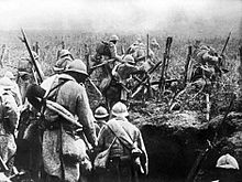
World War I or the First World War (28 July 1914 – 11 November 1918) was a global conflict between two coalitions: the Allies and the Central Powers. Fighting took place throughout Europe, the Middle East, Africa, the Pacific, and parts of Asia. One of the deadliest wars in history, it resulted in an estimated 9 million soldiers dead and 23 million wounded, plus up to 8 million civilian deaths from numerous causes including genocide. The movement of large numbers of troops and civilians during the war was a major factor in spreading the 1918 Spanish flu pandemic.
Increasing diplomatic tensions between the European great powers reached a breaking point on 28 June 1914, when a Bosnian Serb named Gavrilo Princip assassinated Archduke Franz Ferdinand, heir to the Austro-Hungarian throne. Austria-Hungary held Serbia responsible, and declared war on 28 July. Russia came to Serbia's defence, and by 4 August, Germany, France, and Britain were drawn into the war, with the Ottoman Empire joining in November of the same year. Germany's strategy in 1914 was to first defeat France, then transfer forces to the Russian front. However, this failed, and by the end of 1914, the Western Front consisted of a continuous line of trenches stretching from the English Channel to Switzerland. The Eastern Front was more dynamic, but neither side could gain a decisive advantage, despite costly offensives. As the war expanded to more fronts, Bulgaria, Italy, Romania, Greece and others joined in from 1915 onward. (Full article...) -
The international community is a term used in geopolitics and international relations to refer to a broad group of people and governments of the world. (Full article...)
-

The World Bank Group (WBG) is a family of five international organizations that make leveraged loans to developing countries. It is the largest and best-known development bank in the world and an observer at the United Nations Development Group. The bank is headquartered in Washington, D.C., in the United States. It provided around $98.83 billion in loans and assistance to "developing" and transition countries in the 2021 fiscal year. The bank's stated mission is to achieve the twin goals of ending extreme poverty and building shared prosperity. Total lending as of 2015 for the last 10 years through Development Policy Financing was approximately $117 billion. Its five organizations are- the International Bank for Reconstruction and Development (IBRD),
- the International Development Association (IDA),
- the International Finance Corporation (IFC),
- the Multilateral Investment Guarantee Agency (MIGA) and
- the International Centre for Settlement of Investment Disputes (ICSID).
-
A free trade area is the region encompassing a trade bloc whose member countries have signed a free trade agreement (FTA). Such agreements involve cooperation between at least two countries to reduce trade barriers, import quotas and tariffs, and to increase trade of goods and services with each other. If natural persons are also free to move between the countries, in addition to a free trade agreement, it would also be considered an open border. It can be considered the second stage of economic integration.
Customs unions are a special type of free trade area. All such areas have internal arrangements which parties conclude in order to liberalize and facilitate trade among themselves. The crucial difference between customs unions and free trade areas is their approach to third parties. While a customs union requires all parties to establish and maintain identical external tariffs with regard to trade with non-parties, parties to a free trade area are not subject to this requirement. Instead, they may establish and maintain whatever tariff regime applying to imports from non-parties as deemed necessary. In a free trade area without harmonized external tariffs, to eliminate the risk of trade deflection, parties will adopt a system of preferential rules of origin. (Full article...) -
The Cricket World Cup (officially known as ICC Men's Cricket World Cup) is the international championship of One Day International (ODI) cricket. The event is organised by the sport's governing body, the International Cricket Council (ICC), every four years, with preliminary qualification rounds leading up to a finals tournament. The tournament is one of the world's most viewed sporting events and considered as the "flagship event of the international cricket calendar" by the ICC. It is widely considered the pinnacle championship of the sport of cricket.
The first World Cup was organised in England in June 1975, with the first ODI cricket match having been played only four years earlier. However, a separate Women's Cricket World Cup had been held two years before the first men's tournament, and a tournament involving multiple international teams had been held as early as 1912, when a triangular tournament of Test matches was played between Australia, England and South Africa. The first three World Cups were held in England. From the 1987 tournament onwards, hosting has been shared between countries under an unofficial rotation system, with fourteen ICC members having hosted at least one match in the tournament. (Full article...) -

The World Rally Championship (abbreviated as WRC) is an international rallying series owned and governed by the FIA. Inaugurated in 1973, it is the second oldest of the FIA's world championships after Formula One. Each season lasts one calendar year, and separate championship titles are awarded to drivers, co-drivers and manufacturers. There are also two support championships, WRC2 and WRC3, which are contested on the same events and stages as the WRC, but with progressively lower maximum performance and running costs of the cars permitted. Junior WRC is also contested on five events of the World Rally Championship calendar.
A WRC season typically consists of 13 three- to four-day rally events driven on surfaces ranging from gravel and tarmac to snow and ice. Each rally is usually split into 15–25 special stages which are run against the clock on up to 350 kilometres (220 mi) of closed roads. (Full article...) -
The Second Industrial Revolution, also known as the Technological Revolution, was a phase of rapid scientific discovery, standardisation, mass production and industrialisation from the late 19th century into the early 20th century. The First Industrial Revolution, which ended in the middle of the 19th century, was punctuated by a slowdown in important inventions before the Second Industrial Revolution in 1870. Though a number of its events can be traced to earlier innovations in manufacturing, such as the establishment of a machine tool industry, the development of methods for manufacturing interchangeable parts, as well as the invention of the Bessemer process and open hearth furnace to produce steel, the Second Industrial Revolution is generally dated between 1870 and 1914 (the beginning of World War I).
Advancements in manufacturing and production technology enabled the widespread adoption of technological systems such as telegraph and railroad networks, gas and water supply, and sewage systems, which had earlier been limited to a few select cities. The enormous expansion of rail and telegraph lines after 1870 allowed unprecedented movement of people and ideas, which culminated in a new wave of globalization. In the same time period, new technological systems were introduced, most significantly electrical power and telephones. The Second Industrial Revolution continued into the 20th century with early factory electrification and the production line; it ended at the beginning of World War I. (Full article...)


General images -
-
 Ajloun Castle, Jordan
 -

-
 A view of Earth with different layers of its atmosphere visible: the troposphere with its clouds casting shadows, a band of stratospheric blue sky at the horizon, and a line of green airglow of the lower thermosphere around an altitude of 100 km, at the edge of space (from Earth)
 -
 Earth's land use for human agriculture in 2019 (from Earth)
 -
 Empires of the world in 1898
 -
 Taj Mahal, Mughal Empire, India
 -
 A view of Earth with its global ocean and cloud cover, which dominate Earth's surface and hydrosphere; at Earth's polar regions, its hydrosphere forms larger areas of ice cover. (from Earth)
 -
 An artist's rendering of a protoplanetary disk (from History of Earth)
 -
 A schematic view of Earth's magnetosphere with solar wind flowing from left to right (from Earth)
 -
 A pillar at Göbekli Tepe
 -
 A 2012 artistic impression of the early Solar System's protoplanetary disk from which Earth and other Solar System bodies were formed (from Earth)
 -

-

-

-
 Earth's western hemisphere showing topography relative to Earth's center instead of to mean sea level, as in common topographic maps (from Earth)
 -
 Cross-section through a liposome (from History of Earth)
 -

-
 Graph showing range of estimated partial pressure of atmospheric oxygen through geologic time (from History of Earth)
 -
 Ming dynasty section, Great Wall of China
 -
 Obelisk of Axum, Ethiopia
 -
 Dinosaurs were the dominant terrestrial vertebrates throughout most of the Mesozoic (from History of Earth)
 -

-
 Angkor Wat temple complex, Cambodia, early 12th century
 -
 Great Mosque of Kairouan, Tunisia, founded 670 CE
 -
 Florence, birthplace of the Italian Renaissance
 -
 Artist's rendition of an oxinated fully-frozen Snowball Earth with no remaining liquid surface water. (from History of Earth)
 -
 Vitruvian Man by Leonardo da Vinci epitomizes the advances in art and science seen during the Renaissance. (from History of Earth)
 -
 The replicator in virtually all known life is deoxyribonucleic acid. DNA is far more complex than the original replicator and its replication systems are highly elaborate. (from History of Earth)
 -
 Geologic map of North America, color-coded by age. From most recent to oldest, age is indicated by yellow, green, blue, and red. The reds and pinks indicate rock from the Archean.
 -
 Trilobites first appeared during the Cambrian period and were among the most widespread and diverse groups of Paleozoic organisms. (from History of Earth)
 -
 A banded iron formation from the 3.15 Ga Moodies Group, Barberton Greenstone Belt, South Africa. Red layers represent the times when oxygen was available; gray layers were formed in anoxic circumstances. (from History of Earth)
 -
 Artist's conception of Hadean Eon Earth, when it was much hotter and inhospitable to all forms of life. (from History of Earth)
 -
 Machu Picchu, Inca Empire, Peru
 -

-
 Shanghai. China urbanized rapidly in the 21st century.
 -
 Standing Buddha from Gandhara, 2nd century CE
 -
 Artist's impression of a Hadean landscape with the relatively newly formed Moon still looming closely over Earth and both bodies sustaining strong volcanism. (from History of Earth)
 -

-
 Satellite time lapse imagery of Earth's rotation showing axis tilt (from Earth)
 -

-
 The pale orange dot, an artist's impression of the early Earth which might have appeared orange through its hazy methane rich prebiotic second atmosphere. Earth's atmosphere at this stage was somewhat comparable to today's atmosphere of Titan. (from History of Earth)
 -
 Earth's night-side upper atmosphere appearing from the bottom as bands of afterglow illuminating the troposphere in orange with silhouettes of clouds, and the stratosphere in white and blue. Next the mesosphere (pink area) extends to the orange and faintly green line of the lowest airglow, at about one hundred kilometers at the edge of space and the lower edge of the thermosphere (invisible). Continuing with green and red bands of aurorae stretching over several hundred kilometers. (from Earth)
 -
Pale orange dot, an artist's impression of Early Earth, featuring its tinted orange methane-rich early atmosphere (from Earth)
-

-

-
 "Lucy", the first Australopithecus afarensis skeleton found. Lucy was only 1.06 m (3 ft 6 in) tall.
 -
 Artist's impression of Earth during the later Archean, the largely cooled planetary crust and water-rich barren surface, marked by volcanoes and continents, features already round microbialites. The Moon, still orbiting Earth much closer than today and still dominating Earth's sky, produced strong tides. (from History of Earth)
 -
 Artist's conception of Devonian flora (from History of Earth)
 -
 First airplane, the Wright Flyer, flew on 17 December 1903.
 -
 A 580 million year old fossil of Spriggina floundensi, an animal from the Ediacaran period. Such life forms could have been ancestors to the many new forms that originated in the Cambrian Explosion. (from History of Earth)
 -
 A composite image of artificial light emissions at night on a map of Earth (from Earth)
 -
 The Pantheon, originally a Roman temple, now a Catholic church
 -
 Pangaea was a supercontinent that existed from about 300 to 180 Ma. The outlines of the modern continents and other landmasses are indicated on this map. (from History of Earth)
 -
 An artist's impression of ice age Earth at glacial maximum. (from History of Earth)
 -

-
 Olmec colossal head, now at the Museo de Antropología de Xalapa
 -
 Chloroplasts in the cells of a moss (from History of Earth)
 -
 Chennakesava Temple, Belur, India
 -
 Last Moon landing: Apollo 17 (1972)
 -
 An animation of the changing density of productive vegetation on land (low in brown; heavy in dark green) and phytoplankton at the ocean surface (low in purple; high in yellow) (from Earth)
 -
 A reconstruction of Pannotia (550 Ma). (from History of Earth)
 -

-
 Notre-Dame de Paris, France
 -
 A composite image of Earth, with its different types of surface discernible: Earth's surface dominating Ocean (blue), Africa with lush (green) to dry (brown) land and Earth's polar ice in the form of Antarctic sea ice (grey) covering the Antarctic or Southern Ocean and the Antarctic ice sheet (white) covering Antarctica. (from Earth)
 -
 Artist's impression of the enormous collision that probably formed the Moon (from History of Earth)
 -

-
 Fall of the Berlin Wall, 1989
 -
 Battle during the 1281 Mongol invasion of Japan
 -
 Tracy Caldwell Dyson, a NASA astronaut, observing Earth from the Cupola module at the International Space Station on 11 September 2010 (from Earth)
 -
 Tiktaalik, a fish with limb-like fins and a predecessor of tetrapods. Reconstruction from fossils about 375 million years old. (from History of Earth)
 -

-
 View of Earth from the Moon by the Lunar Reconnaissance Orbiter (from Earth)
 -
 Persepolis, Achaemenid Empire, 6th century BCE
 -
 Lithified stromatolites on the shores of Lake Thetis, Western Australia. Archean stromatolites are the first direct fossil traces of life on Earth. (from History of Earth)
 -

-
 Earth's axial tilt causing different angles of seasonal illumination at different orbital positions around the Sun (from Earth)
 -
 Change in average surface air temperature and drivers for that change. Human activity has caused increased temperatures, with natural forces adding some variability. (from Earth)
 -
 A computer-generated image mapping the prevalence of artificial satellites and space debris around Earth in geosynchronous and low Earth orbit (from Earth)
 -
 A map of heat flow from Earth's interior to the surface of Earth's crust, mostly along the oceanic ridges (from Earth)
 -
 Map of peopling of the world (Southern Dispersal paradigm), in thousands of years ago.
 -
 A Benin Bronze head from Nigeria
 -
An artist's impression of the Archean, the eon after Earth's formation, featuring round stromatolites, which are early oxygen-producing forms of life from billions of years ago. After the Late Heavy Bombardment, Earth's crust had cooled, its water-rich barren surface is marked by continents and volcanoes, with the Moon still orbiting Earth half as far as it is today, appearing 2.8 times larger and producing strong tides. (from Earth)
-
 Great Pyramids of Giza, Egypt
 -
 Japanese depiction of a Portuguese carrack. European maritime innovations led to proto-globalization.
 -
 Yggdrasil, an attempt to reconstruct the Norse world tree which connects the heavens, the world, and the underworld. (from World)
 -
 A reconstruction of human history based on fossil data. (from History of Earth)
 -
 Earth's history with time-spans of the eons to scale (from History of Earth)
 -

-
 Stone monuments (moai) on Rapa Nui, thought to represent high-ranking ancestors (from Human history)
 -
 Image of the physical world, captured by the Hubble Space Telescope (from World)
 -


.svg)


.jpg)


.jpeg)


.jpg)

.jpg)


Megacities of the world -
Hyderabad (/ˈhaɪdərəbæd/ HY-dər-ə-bad; Telugu: [ˈɦaɪ̯daraːbaːd], Urdu: [ˈɦɛːdəɾaːbaːd]) is the capital and largest city of the Indian state of Telangana. It occupies 650 km2 (250 sq mi) on the Deccan Plateau along the banks of the Musi River, in the northern part of Southern India. With an average altitude of 542 m (1,778 ft), much of Hyderabad is situated on hilly terrain around artificial lakes, including the Hussain Sagar lake, predating the city's founding, in the north of the city centre. According to the 2011 census of India, Hyderabad is the fourth-most populous city in India with a population of 6.9 million residents within the city limits, and has a population of 9.7 million residents in the metropolitan region, making it the sixth-most populous metropolitan area in India. With an output of US$74 billion, Hyderabad has the fifth-largest urban economy in India.
The Qutb Shahi dynasty's Muhammad Quli Qutb Shah established Hyderabad in 1591 to extend the capital beyond the fortified Golconda. In 1687, the city was annexed by the Mughals. In 1724, Asaf Jah I, the Mughal viceroy, declared his sovereignty and founded the Asaf Jahi dynasty, also known as the Nizams. Hyderabad served as the imperial capital of the Asaf Jahis from 1769 to 1948. As capital of the princely state of Hyderabad, the city housed the British Residency and cantonment until Indian independence in 1947. Hyderabad was annexed by the Indian Union in 1948 and continued as a capital of Hyderabad State from 1948 to 1956. After the introduction of the States Reorganisation Act of 1956, Hyderabad was made the capital of the newly formed Andhra Pradesh. In 2014, Andhra Pradesh was split to form the state of Telangana, and Hyderabad became the joint capital of the two states with a transitional arrangement scheduled to end in 2024. Since 1956, the city has housed the Rashtrapati Nilayam, the winter office of the president of India. (Full article...)Did you know -

- ... that the tripartite structure of the National War Labor Board helped the United States keep work stoppages to a minimum during World War II?
- ... that The Oxford Guide to the Book of Common Prayer: A Worldwide Survey made historian Alec Ryrie suspect "there is such a thing as 'Anglicanism' after all"?
- ... that one of the largest and thickest loess plateaus in the world is the Loess Plateau in China?
- ... that the Cure's Shows of a Lost World has grossed $37.5 million and become their highest-grossing tour to date, despite the band's refusal to use Ticketmaster's dynamic pricing?
- ... that a Brazilian priest died while attempting to break the cluster-ballooning world record, in order to fund a spiritual rest-stop for truckers?
- ... that goalkeeper Daniela Solera had the most touches of any Costa Rican player in their opening match of the 2023 World Cup?
- ... that the final of the 2009 IBSF women's snooker championship was interrupted so that drug tests could be conducted on the players?
- ... that people in Madagascar wrestle bulls to commemorate the unearthing of ancestral corpses?
Countries of the world -

Zambia, officially the Republic of Zambia, is a landlocked country at the crossroads of Central, Southern and East Africa. It is typically referred to being in South-Central Africa or Southern Africa. It is bordered to the north by the Democratic Republic of the Congo, Tanzania to the north-east, Malawi to the east, Mozambique to the southeast, Zimbabwe and Botswana to the south, Namibia to the southwest, and Angola to the west. The capital city of Zambia is Lusaka, located in the south-central part of Zambia. The population is concentrated mainly around Lusaka in the south and the Copperbelt Province to the north, the core economic hubs of the country.
Originally inhabited by Khoisan peoples, the region was affected by the Bantu expansion of the thirteenth century. Following European explorers in the 18th century, the British colonised the region into the British protectorates of Barotziland–North-Western Rhodesia and North-Eastern Rhodesia towards the end of the 19th century. These were merged in 1911 to form Northern Rhodesia. For most of the colonial period, Zambia was governed by an administration appointed from London with the advice of the British South Africa Company. (Full article...)
The Seven Wonders of Ukraine (Ukrainian: Сім чудес України [ˈsʲim tʃʊˈdɛs ʊkrɐˈjinɪ]) are seven historical and cultural monuments of Ukraine, which were chosen in the Seven Wonders of Ukraine contest held in July, 2007. This was the first public contest of that kind which was followed by the Seven Natural Wonders of Ukraine, the Seven Wonderful Routes of Ukraine, and the Seven Wonderful Castles of Ukraine. All nominated sites are publicly owned protected areas of at least regional level, available for tourism.
The voting for all contests consisted of two parts: experts in Ukraine voted for their seven best sites, and internet users voted for their seven favorite sites on the official website. (Full article...)Related portals
Protected areas of the world -
-
Protected areas of Slovakia are areas that need protection because of their environmental, historical or cultural value to the nation. Protected areas in Slovakia are managed by institutions and organizations governed by the Ministry of the Environment.
Types of protected areas:- National Park (Slovak: Národný park; abbr. NP)
- Protected Landscape Area (Chránená krajinná oblasť; CHKO)
- National Nature Reserve (Národná prírodná rezervácia; NPR)
- Nature Reserve (Prírodná rezervácia; PR)
- National Nature Monument (Národná prírodná pamiatka; NPP)
- Nature Monument (Prírodná pamiatka; PP)
- Protected Site (Chránený areál; CHA)
- Protected Landscape Element (Chránený krajinný prvok; CHKP)
- Protected Bird Area* (Chránené vtáčie územie; CHVÚ) *Technically Special Protection Area (SPA) under the EU Bird's Directive
- Protected Tree (Chránený strom; CHS)
-
Protected areas of Libya include any geographical area protected for a specific use.
Most protected areas are intended for the conservation of flora and fauna. Libya's national parks and nature reserves are maintained by the "Technical Committee of Wildlife and National Parks" which was created in 1990, as part of the General Secretariat of Agricultural Reclamation and Land Reform. (Full article...) -
-
Protected areas of Eswatini include any geographical area protected for a specific use inside the landlocked country of Eswatini, in southern Africa.
Within Eswatini there is a mix of national, private and community-owned protected areas. They include national parks, nature reserves, wildlife sanctuaries and game reserves. (Full article...) -
A National Biodiversity Conservation Area (NBCA) is an environmentally protected area in Laos. There are all together 21 different NBCAs in Laos, protecting 29,775 square kilometers. Another 10 NBCAs have been proposed, many of them being treated by authorities as though they were already officially protected. (Full article...)
-

Network of protected areas in Albania (2020)
Despite being a relatively small country, Albania is exceedingly rich in biodiversity. Its ecosystems and habitats support over 5,550 species of vascular and non-vascular plants and more than 15,600 species of coniferous and non-coniferous evergreens, most of which are threatened at global and European levels. The country has made recent efforts to expand its network of protected areas which now include: 11 national parks, 1 marine park, 718 nature monuments, 23 managed nature reserves, 11 protected landscapes, 4 World Heritage Sites, 4 Ramsar sites and other protected areas of various categories, that when combined, account for 21.36% of the territory. Furthermore, a biosphere reserve, 45 important plant areas and 16 important bird areas are found in the country.
Meanwhile, the central government has proclaimed the Coastline and the Tirana Greenbelt as areas of national importance. (Full article...) -
The Protected areas of New South Wales include both terrestrial and marine protected areas. there are 225 national parks in New South Wales. A number established since the late 1970s followed campaigns by local residents and environmentalists.
Based on the Collaborative Australian Protected Area Database (CAPAD) 2020 data there are 2136 separate terrestrial protected areas with a total land area of 7,696,641 hectares (19,018,810 acres) (9.61% of the state's area). CAPAD data also shows 18 marine protected areas with a total area of 348,849 hectares (862,020 acres), covering 39.63% of NSW waters. (Full article...) -
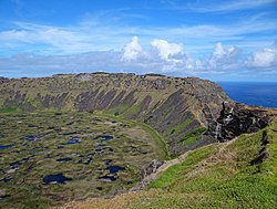
Rano Kau, Parque National Rapa Nui, Easter Island
The protected areas of Chile are areas that have natural beauty or significant historical value protected by the government of Chile. These protected areas cover over 140,000 km2 (54,054 sq mi), which is 19% of the territory of Chile. The National System of Protected Wild Areas (SNASPE by its Spanish acronym) is regulated by law #18,362 passed in 1984, and administered by the National Forest Corporation (CONAF).
There are three types of territories: (Full article...) -

There are numerous parks throughout the sovereign island country of Singapore. This is a list of parks in Singapore that are currently existing and have articles on Wikipedia. Most parks in Singapore are managed by the National Parks Board, although smaller neighbourhood parks are managed by the Housing Development Board. Most of these parks are connected via the Park Connector Network (PCN). (Full article...) -

The sun over the Lake Niassa Reserve
Protected areas in Mozambique are known as conservation areas, and are currently grouped into national parks, national reserves, forest reserves, wildlife utilisation areas (coutadas), community conservation areas, and private game farms (fazendas de bravio). There are also a number of areas that have been declared as protected areas under a variety of different legislation, which for reasons of simplicity are here grouped together as "other protected areas." Under the Conservation Law of 2014 (Law 16/2014 of June 20), protected areas will need to be reclassified into a much more flexible series of new categories which are closer to the international system used by the IUCN. International initiatives such as transfrontier parks are grouped at the end of the page. (Full article...) -
The Protected areas of Kyrgyzstan are regulated by the law on specially protected natural areas of 2 May 2011, last modified on 2 June 2018. In total, they cover 14,761.216 km2 (5,699.337 sq mi) and account for 7.38% of the country's total area (as of 2017). The first protected area in Kyrgyzstan (Issyk-Kul) was established in 1948. According to the Government Decree on Priorities of Conservation of Biological Diversity and the relevant Action Plan for 2014-2024 the target area for the protected areas in Kyrgyzstan is 10 percent of the country’s area by 2024.
The protected areas are subdivided into seven categories: (Full article...) -
This is a list of protected areas of Romania.
About 5.18% of the area of Romania has a protected status (12,360 km2), including the Danube Delta, which makes half of these areas (2.43% of Romania's area). (Full article...) -
As of present, there are around 400 protected areas in Pakistan that are recognized by IUCN. The total protected land area represents 13% of Pakistan's landmass as of 2020, The Government of Pakistan plans to increase it to at least 15% by 2023. As a signatory of the UN Convention on Biological Diversity, Pakistan is committed to expanding its protected areas to encompass 17% of its total territory by the year 2030. This ambitious goal aims to ensure the long-term conservation of nature, safeguard vital ecosystem services, and preserve the cultural values associated with these protected areas. (Full article...)
-
This is a list of protected areas of Afghanistan.
- Ab-i-Estada Nature Reserve, Ghazni Province
- Ajar Valley Nature Reserve, Bamyan Province
- Bamiyan National Heritage Park, Bamyan Province
- Bamiyan Plateau Protected Landscape, Bamyan Province
- Band-e Amir National Park, Bamyan Province
- Darqad (Takhar) Wildlife Reserve, Takhar Province
- Dasht-i-Nawar Waterfowl Sanctuary, Ghazni Province
- Hamun-i-Puzak Waterfowl Sanctuary, Farah and Nimroz provinces
- Imam Sahib (Kunduz) Wildlife Reserve, Kunduz Province
- Khulm Landmark Protected Area, Balkh Province
- Koh-e Baba (Shah Foladi) Protected Landscape, Bamyan province
- Kol-i-Hashmat Khan Waterfowl Sanctuary, Kabul Province
- Northwest Afghanistan Game Managed Reserve, Herat Province
- Nuristan National Park and Wildlife Reserve, Nuristan Province
- Pamir-i-Buzurg Wildlife Reserve, Badakhshan Province
- Registan Desert Wildlife Managed Reserve, Kandahar Province
- Wakhan National Park, Badakhshan Province
- Zadran National Reserve, Paktia Province
-

Flamingos at the Ras Al Khor Wildlife Sanctuary
This is a list of protected areas of United Arab Emirates:- Abu Dhabi Mangrove and Coastal Wetland Reserve
- Ain al Faydah National Park
- Al Awir Nature Reserve
- Al Khawanij Nature Reserve
- Al Maha Nature Reserve
- Al Marmoom Desert Conservation Reserve
- Al Wohoosh Desert Conservation Reserve
- Dubai Desert Conservation Reserve National Park
- Hatta Nature Reserve
- Jabal Ali Wildlife Sanctuary
- Khor Kalba Nature Reserve
- Marawah Marine Protected Area
- Mushrif National Park
- Nadd Al Sheba Nature Reserve
- Rams Lagoon Reserve
- Ras Al Khor Wildlife Sanctuary
- Wadi Wurayah National Park
- Zirkuh Island Bird Sanctuary
.svg)


.jpg)

Selected world maps
-
 A plate tectonics map with volcano locations indicated with red circles
 -
 Index map from the International Map of the World (1:1,000,000 scale)
 -
 Only a few of the largest large igneous provinces appear (coloured dark purple) on this geological map, which depicts crustal geologic provinces as seen in seismic refraction data
 -
 1516 map of the world by Martin Waldseemüller
 -
 United Nations Human Development Index map by country (2016)
 -
 The Goode homolosine projection is a pseudocylindrical, equal-area, composite map projection used for world maps.
 -
 The world map by Gerardus Mercator (1569), the first map in the well-known Mercator projection
 -
 Time zones of the world
 -
 Mollweide projection of the world


World records
- List of Olympic records in athletics
- List of world records in athletics
- List of junior world records in athletics
- List of world records in masters athletics
- List of world youth bests in athletics
- List of IPC world records in athletics
- List of world records in canoeing
- List of world records in chess
- List of cycling records
- List of world records in track cycling
- List of world records in finswimming
- List of world records in juggling
- List of world records in rowing
- List of world records in speed skating
- List of world records in swimming
- List of IPC world records in swimming
- List of world records in Olympic weightlifting
Topics

Continents of Earth | ||||||||
|---|---|---|---|---|---|---|---|---|
| ||||||||
| ||||||||
| ||||||||


| Cenozoic Era (present–66.0 Ma) |
| ||||||||||||
|---|---|---|---|---|---|---|---|---|---|---|---|---|---|
| Mesozoic Era (66.0–252 Ma) |
| ||||||||||||
| Paleozoic Era (252–539 Ma) |
| ||||||||||||
| Proterozoic Eon (539 Ma–2.5 Ga) |
| ||||||||||||
| Archean Eon (2.5–4 Ga) | |||||||||||||
| Hadean Eon (4–4.6 Ga) | |||||||||||||
ka = kiloannum (thousands years ago); Ma = megaannum (millions years ago); Ga = gigaannum (billions years ago). See also: Geologic time scale • | |||||||||||||
| Locations | ||
|---|---|---|
| Related | ||

| |||||||||||||||||||
| |||||||||||||||||||
| |||||||||||||||||||

Economic classification of countries | |||||
|---|---|---|---|---|---|
| Three-World Model | |||||
| Gross domestic product (GDP) |
| ||||
| Gross national income (GNI) | |||||
| Wages | |||||
| Wealth | |||||
| Other national accounts | |||||
| Human development | |||||
| Digital divide | |||||
| Net international investment position (NIIP) | |||||
| Technological |
| ||||
|---|---|---|---|---|---|
| Sociological | |||||
| Ecological |
| ||||
| Biological |
| ||||
| Astronomical | |||||
| Eschatological |
| ||||
| Others |
| ||||
| Fictional | |||||
| Organizations | |||||
Categories

Wikimedia
The following Wikimedia Foundation sister projects provide more on this subject:
-
 Commons
Free media repository -
 Wikibooks
Free textbooks and manuals -
 Wikidata
Free knowledge base -
 Wikinews
Free-content news -
 Wikiquote
Collection of quotations -
 Wikisource
Free-content library -
 Wikispecies
Directory of species -
 Wikiversity
Free learning tools -
 Wikivoyage
Free travel guide -
 Wiktionary
Dictionary and thesaurus


