
Kangxiwar: Difference between revisions
Voidvector (talk | contribs) mNo edit summary |
Voidvector (talk | contribs) |
||
| Line 48: | Line 48: | ||
Before modern era, the area was a thoroughfare of the caravan trade route between [[Leh]] and [[Tarim Basin]]. It was previously referred to as ''Sumgal''.<ref name="VisserVisser-Hooft1935">{{cite book|author1=Jeannette Hooft Visser|author2=Jenny Visser-Hooft|title=Wissenschaftliche ergebnisse der Niederländischen Expeditionen in den Karakorum und die angrenzenden gebiete in den jahren 1922, 1925 und 1929/30|url=https://books.google.com/books?id=NPpWAAAAMAAJ|year=1935|publisher=In kommission bei F.A. Brockhaus|page=14|language=de|quote=Sie folgten dem Kara-kash-Tal einige Kilometer nordwärts, um dann von Sumgal (gegenwärtig Kengshewar) über den Ilchi-davan (vermutlich der Paß, der jetzt Hindutash genannt wird) über das K'un-lun-Gebirge bis Bushia (jetzt Pusha)}}</ref> Literally meaning "three fords" in [[Tibetan language]],<ref>{{cite book|title=Journal of the Royal Asiatic Society of Great Britain and Ireland|url=https://books.google.com/books?id=IHWxqY5dmoMC&pg=PA91|year=1863|publisher=Royal Asiatic Society of Great Britain & Ireland|page=91|quote=Gsum "three" ... It is a name very frequent in Tíbet ... Súmgal, in Turkistán ... -- gsum rgal, "the three fords."}}</ref> it was a historical [[ford (crossing)|ford]] and horse-changing station{{cn}} located downstream of Kangxiwar on the right (north?) bank of the [[Karakash River]]<ref name="SchlagintweitSchlagintweit1863">{{cite book|author1=Adolf von Schlagintweit|author2=Robert von Schlagintweit|title=Results of a Scientific Mission to India and High Asia: Route-book of the western parts of the Himalaya, Tibet, and Central Asia : and geographical glossary from the languages of India and Tibet, including the phonetic transcription and interpretation|url=https://books.google.com/books?id=_JtLAQAAMAAJ&pg=PA122|year=1863|publisher=F. A. Brockhaus|page=122|quote=A Sumgal, 36° 8', 78° 5'; 13,215 ft, on the right bank of the Karakásh river (fuel and grass abundant).}}</ref><ref name="Trotter1878">{{cite journal|last1=Trotter|first1=H.|title=On the Geographical Results of the Mission to Kashghar, under Sir T. Douglas Forsyth in 1873-74|journal=Journal of the Royal Geographical Society of London|volume=48|year=1878|pages=183|issn=02666235|doi=10.2307/1798763|quote=On the Kárákásh River, above Fotásh, is a camping-ground called Sumgal, from which Robert Schlagintweit crossed the Kuen Luen Range by the Hindu-tágh Pass, estimated by him at 17,379 feet high. ... The road by the Hindu-tágh Pass can only be used by foot-passengers.}}</ref> just before it enters the [[Aksai Chin]] plateau<ref name=trotter1878-U8>{{Harv|Trotter|1878|p=U8}}</ref> |
Before modern era, the area was a thoroughfare of the caravan trade route between [[Leh]] and [[Tarim Basin]]. It was previously referred to as ''Sumgal''.<ref name="VisserVisser-Hooft1935">{{cite book|author1=Jeannette Hooft Visser|author2=Jenny Visser-Hooft|title=Wissenschaftliche ergebnisse der Niederländischen Expeditionen in den Karakorum und die angrenzenden gebiete in den jahren 1922, 1925 und 1929/30|url=https://books.google.com/books?id=NPpWAAAAMAAJ|year=1935|publisher=In kommission bei F.A. Brockhaus|page=14|language=de|quote=Sie folgten dem Kara-kash-Tal einige Kilometer nordwärts, um dann von Sumgal (gegenwärtig Kengshewar) über den Ilchi-davan (vermutlich der Paß, der jetzt Hindutash genannt wird) über das K'un-lun-Gebirge bis Bushia (jetzt Pusha)}}</ref> Literally meaning "three fords" in [[Tibetan language]],<ref>{{cite book|title=Journal of the Royal Asiatic Society of Great Britain and Ireland|url=https://books.google.com/books?id=IHWxqY5dmoMC&pg=PA91|year=1863|publisher=Royal Asiatic Society of Great Britain & Ireland|page=91|quote=Gsum "three" ... It is a name very frequent in Tíbet ... Súmgal, in Turkistán ... -- gsum rgal, "the three fords."}}</ref> it was a historical [[ford (crossing)|ford]] and horse-changing station{{cn}} located downstream of Kangxiwar on the right (north?) bank of the [[Karakash River]]<ref name="SchlagintweitSchlagintweit1863">{{cite book|author1=Adolf von Schlagintweit|author2=Robert von Schlagintweit|title=Results of a Scientific Mission to India and High Asia: Route-book of the western parts of the Himalaya, Tibet, and Central Asia : and geographical glossary from the languages of India and Tibet, including the phonetic transcription and interpretation|url=https://books.google.com/books?id=_JtLAQAAMAAJ&pg=PA122|year=1863|publisher=F. A. Brockhaus|page=122|quote=A Sumgal, 36° 8', 78° 5'; 13,215 ft, on the right bank of the Karakásh river (fuel and grass abundant).}}</ref><ref name="Trotter1878">{{cite journal|last1=Trotter|first1=H.|title=On the Geographical Results of the Mission to Kashghar, under Sir T. Douglas Forsyth in 1873-74|journal=Journal of the Royal Geographical Society of London|volume=48|year=1878|pages=183|issn=02666235|doi=10.2307/1798763|quote=On the Kárákásh River, above Fotásh, is a camping-ground called Sumgal, from which Robert Schlagintweit crossed the Kuen Luen Range by the Hindu-tágh Pass, estimated by him at 17,379 feet high. ... The road by the Hindu-tágh Pass can only be used by foot-passengers.}}</ref> just before it enters the [[Aksai Chin]] plateau<ref name=trotter1878-U8>{{Harv|Trotter|1878|p=U8}}</ref> |
||
During the 1962 war, the PLA's regional headquarter was operated out of Kangxiwar,<ref name="MottKim2006">{{cite book|author1=W. Mott|author2=J. Kim|title=The Philosophy of Chinese Military Culture: Shih vs. Li|url=https://books.google.com/books?id=lfLIAAAAQBAJ&pg=PA143|date=2 April 2006|publisher=Palgrave Macmillan US|isbn=978-1-4039-8313-8|pages=143–|quote-In response, China deployed two infantry regiments, several autonomous infantry battalions, and supporting artillery--about 6,300 soldiers--under the Xinjiang Military Region's Kangxiwa (Kangxiwar) Headquarters.}}</ref> although certain activities were supervised directly by [[People's Liberation Army General Staff Department]].<ref name="Fravel2008">{{cite book|author=M. Taylor Fravel|title=Strong Borders, Secure Nation: Cooperation and Conflict in China's Territorial Disputes|url=https://books.google.com/books?id=02Hjr6RUckwC&pg=PA186|date=25 August 2008|publisher=Princeton University Press|isbn=1-4008-2887-2|page=186|quote=Moreover, if attacked, the PLA troops at Galwan were permitted to report directly to the GSD, not through the normal chain of command via the Kangxiwar headquarters and Xinjiang MD.}}</ref> |
|||
==See also== |
==See also== |
||
Revision as of 18:19, 7 January 2020
This article has multiple issues. Please help improve it or discuss these issues on the talk page. (Learn how and when to remove these messages)
|
Kangxiwar | |
|---|---|
 Kangxiwar memorial signage | |
 Kangxiwar  Kangxiwar | |
| Coordinates: 36°12′N 78°45′E / 36.200°N 78.750°E | |
| Country | China |
| Region | Xinjiang |
| Prefecture | Hotan Prefecture |
| County | Pishan County |
| Kangxiwar | |||||||
|---|---|---|---|---|---|---|---|
| Traditional Chinese | 康西瓦 | ||||||
| Simplified Chinese | 康西瓦 | ||||||
| |||||||
Kangxiwar (formerly Kengshewar[1]) is the location of a deserted town on the southwest side of the Kunlun Mountains. It is on the Karakash River in the western Xinjiang Uyghur Autonomous Region of the People's Republic of China. Kangxiwar means "place with mine" in Uyghur.[2]
History
Before modern era, the area was a thoroughfare of the caravan trade route between Leh and Tarim Basin. It was previously referred to as Sumgal.[1] Literally meaning "three fords" in Tibetan language,[3] it was a historical ford and horse-changing station[citation needed] located downstream of Kangxiwar on the right (north?) bank of the Karakash River[4][5] just before it enters the Aksai Chin plateau[6]
During the 1962 war, the PLA's regional headquarter was operated out of Kangxiwar,[7] although certain activities were supervised directly by People's Liberation Army General Staff Department.[8]
See also
-
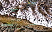 NASA satellite image showing the towns of Sumgal in Ladakh and Pusa in southwestern Hotan, and the Hindu-tash Pass connecting them. The pass is marked in bright red.
 -
![Details of a map of Kashmir (1878) showing the Hindutash Pass and Hotan as well as the northern border regions of the British Indian Empire (which included the Kashmir region).[6] The international border is shown in the two-toned purple and pink band. The mountain passes are shown in bright red. Warning the lat/long information is not everywhere correct.](//upload.wikimedia.org/wikipedia/commons/thumb/4/43/Hindutagh-pass-aksai-chin-center2-1873.jpg/126px-Hindutagh-pass-aksai-chin-center2-1873.jpg) Details of a map of Kashmir (1878) showing the Hindutash Pass and Hotan as well as the northern border regions of the British Indian Empire (which included the Kashmir region).[6] The international border is shown in the two-toned purple and pink band. The mountain passes are shown in bright red. Warning the lat/long information is not everywhere correct.
Details of a map of Kashmir (1878) showing the Hindutash Pass and Hotan as well as the northern border regions of the British Indian Empire (which included the Kashmir region).[6] The international border is shown in the two-toned purple and pink band. The mountain passes are shown in bright red. Warning the lat/long information is not everywhere correct.

![Details of a map of Kashmir (1878) showing the Hindutash Pass and Hotan as well as the northern border regions of the British Indian Empire (which included the Kashmir region).[6] The international border is shown in the two-toned purple and pink band. The mountain passes are shown in bright red. Warning the lat/long information is not everywhere correct.](/wiki/File:Hindutagh-pass-aksai-chin-center2-1873.jpg)
References
Notes
- ^ a b Jeannette Hooft Visser; Jenny Visser-Hooft (1935). Wissenschaftliche ergebnisse der Niederländischen Expeditionen in den Karakorum und die angrenzenden gebiete in den jahren 1922, 1925 und 1929/30 (in German). In kommission bei F.A. Brockhaus. p. 14.
Sie folgten dem Kara-kash-Tal einige Kilometer nordwärts, um dann von Sumgal (gegenwärtig Kengshewar) über den Ilchi-davan (vermutlich der Paß, der jetzt Hindutash genannt wird) über das K'un-lun-Gebirge bis Bushia (jetzt Pusha)
- ^ 国际展望 (Guoji Zhanwang / World Outlook Magazine) (21 March 2005). "专访中国海拔最高的烈士陵园" (in Chinese). Sina Military News. Retrieved 7 January 2020.
康西瓦,维语的意思是"有矿的地方"。
- ^ Journal of the Royal Asiatic Society of Great Britain and Ireland. Royal Asiatic Society of Great Britain & Ireland. 1863. p. 91.
Gsum "three" ... It is a name very frequent in Tíbet ... Súmgal, in Turkistán ... -- gsum rgal, "the three fords."
- ^ Adolf von Schlagintweit; Robert von Schlagintweit (1863). Results of a Scientific Mission to India and High Asia: Route-book of the western parts of the Himalaya, Tibet, and Central Asia : and geographical glossary from the languages of India and Tibet, including the phonetic transcription and interpretation. F. A. Brockhaus. p. 122.
A Sumgal, 36° 8', 78° 5'; 13,215 ft, on the right bank of the Karakásh river (fuel and grass abundant).
- ^ Trotter, H. (1878). "On the Geographical Results of the Mission to Kashghar, under Sir T. Douglas Forsyth in 1873-74". Journal of the Royal Geographical Society of London. 48: 183. doi:10.2307/1798763. ISSN 0266-6235.
On the Kárákásh River, above Fotásh, is a camping-ground called Sumgal, from which Robert Schlagintweit crossed the Kuen Luen Range by the Hindu-tágh Pass, estimated by him at 17,379 feet high. ... The road by the Hindu-tágh Pass can only be used by foot-passengers.
- ^ a b (Trotter 1878, p. U8) harv error: multiple targets (2×): CITEREFTrotter1878 (help)
- ^ W. Mott; J. Kim (2 April 2006). The Philosophy of Chinese Military Culture: Shih vs. Li. Palgrave Macmillan US. pp. 143–. ISBN 978-1-4039-8313-8.
{{cite book}}: Text "quote-In response, China deployed two infantry regiments, several autonomous infantry battalions, and supporting artillery--about 6,300 soldiers--under the Xinjiang Military Region's Kangxiwa (Kangxiwar) Headquarters." ignored (help) - ^ M. Taylor Fravel (25 August 2008). Strong Borders, Secure Nation: Cooperation and Conflict in China's Territorial Disputes. Princeton University Press. p. 186. ISBN 1-4008-2887-2.
Moreover, if attacked, the PLA troops at Galwan were permitted to report directly to the GSD, not through the normal chain of command via the Kangxiwar headquarters and Xinjiang MD.
General sources
- Johnson, W. H. (1867), "Report on His Journey to Ilchí, the Capital of Khotan, in Chinese Tartary", Journal of the Royal Geographical Society of London, 37 (1): 1–47, doi:10.2307/1798517, JSTOR 1798517.
- Schlagintweit, Hermann; Schlagintweit, Adolphe; Schlagintweit, Robert (1861), Results of a Scientific Mission to India and High Asia: undertaken between the years MDCCCLIV and MDCCCLVIII, Leipzig/London: F. A. Brockhaus/Trubner and Co.[permanent dead link].
- Stein, M. Aurel (1909), "Explorations in Central Asia, 1906-8", The Geographical Journal, 34 (1): 5–36, doi:10.2307/1777985, JSTOR 1777985.
- Stein, M. Aurel (1911), "Note on Maps Illustrating Dr. Stein's Explorations in Chinese Turkestan and Kansu", The Geographical Journal, 37 (3): 275–280, doi:10.2307/1777400, JSTOR 1777400.
- Trotter, H. (1878), "On the Geographical Results of the Mission to Kashghar, under Sir T. Douglas Forsyth in 1873-74", Journal of the Royal Geographical Society of London, 48 (2): 173–234, doi:10.2307/1798763, JSTOR 1798763.
- Gazetteer of Kashmir and Ladak compiled under the direction of the Quarter Master | General in India in the Intelligence Branch. First Published in 1890 by the Superintendent of Government Printing, Calcutta. Compiled under the Direction of the Quartermaster -General in India in the Intelligence | Branch. 1890 Ed.
- Report of the Great Trigonometrical Survey of India, 1866, p. 6.
- Map referred to in Art.9 of the Simla Convention between Great Britain, China and Tibet, 1914 signed by the Chinese representative.
- Atlas of the northern frontiers of India . Pg.20
- Himalayan Frontiers by Dorothy Woodman. Pg.67-68