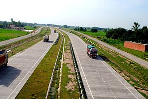
Prayagraj Bypass Expressway

Allahabad Bypass is a 84.708 km (52.635 mi) access controlled highway and forms part of Golden Quadrilateral in India. Construction of road from Km. 158 to 198 (except the Ganges Bridge) has been taken up by National Highways Authority of India with loan assistance from World Bank.[1] The total work was divided into 3 contract packages. The project consists of 2.608 km of 4-lane widening of the existing NH-2 and 82.1 km (51.0 mi) of new construction. The Allahabad Bypass takes off from 158 km (98 mi) of NH-2 (near Kokhraj), runs for 2 km (1.2 mi) along the existing alignment and then for 82.10 km (51.01 mi) along new bypass alignment, north of Allahabad city.[2] It rejoins the existing alignment of NH-2 (near Handia) and runs another 0.608 km (0.378 mi) to end at 242.708 km (150.812 mi) (NH-2 stationing 245 km (152 mi)).
See also
References
- ^ "Allahabad Bypass Project". World Bank.
- ^ "Allahabad Bypass Project, Construction supervision services for road packages expressions of interest". The National Highways Authority of India.
