
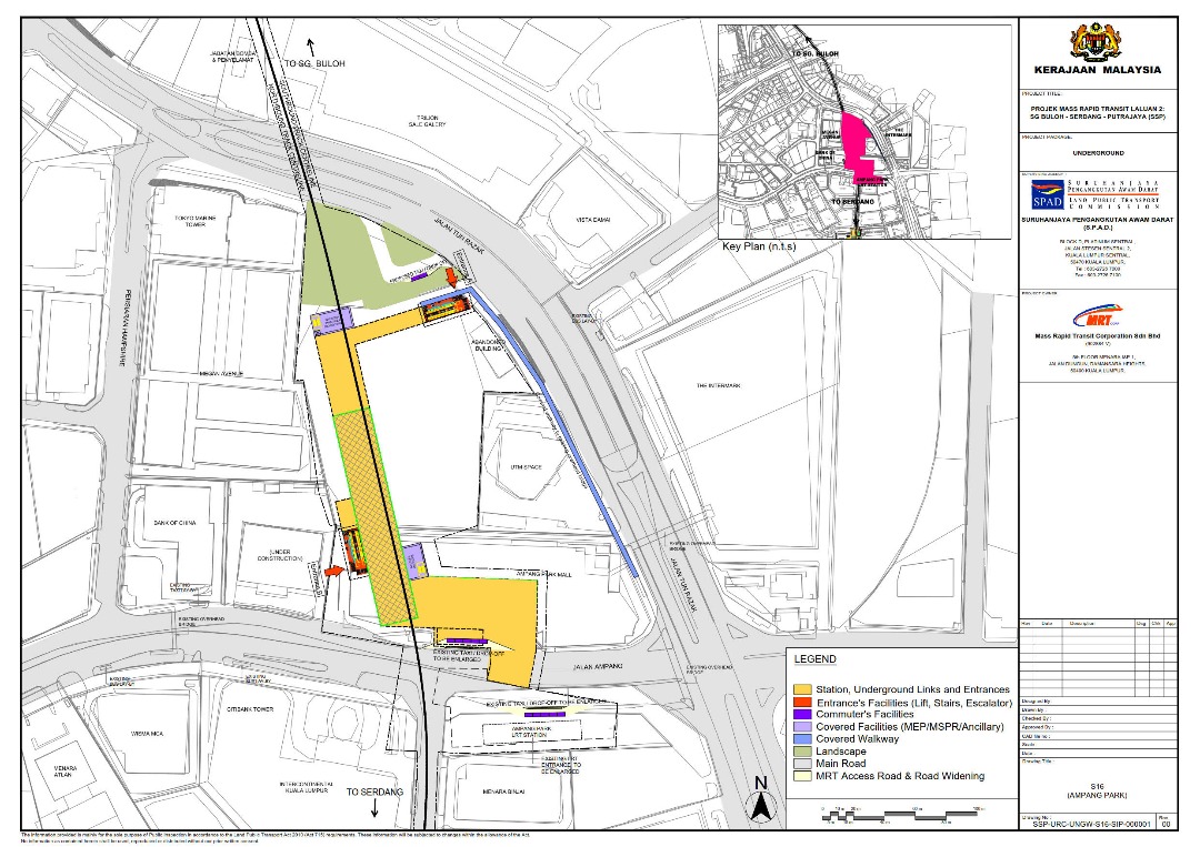
Ampang Park station
This article relies largely or entirely on a single source. (September 2020) |
KJ9 PY20 Ampang Park | |||||||||||||||||||||
|---|---|---|---|---|---|---|---|---|---|---|---|---|---|---|---|---|---|---|---|---|---|
Light rapid transit (LRT) & future Mass rapid transit station | |||||||||||||||||||||
_(cropped).jpg) | |||||||||||||||||||||
| General information | |||||||||||||||||||||
| Location | Jalan Ampang, Kuala Lumpur Malaysia | ||||||||||||||||||||
| Owned by | Prasarana Malaysia (LRT) MRT Corp (MRT) | ||||||||||||||||||||
| Operated by | Rapid Rail | ||||||||||||||||||||
| Line(s) | 5 Kelana Jaya 12 Putrajaya (Under construction) | ||||||||||||||||||||
| Platforms | 1 island platform (LRT) 2 stacked side platforms (MRT) | ||||||||||||||||||||
| Tracks | 2 (LRT) 2 (MRT) | ||||||||||||||||||||
| Construction | |||||||||||||||||||||
| Structure type | KJ9 PY20 Underground | ||||||||||||||||||||
| Parking | Not available | ||||||||||||||||||||
| Accessible | Available | ||||||||||||||||||||
| Other information | |||||||||||||||||||||
| Station code | KJ9 PY20 | ||||||||||||||||||||
| History | |||||||||||||||||||||
| Opened | 1 June 1999 (LRT) | ||||||||||||||||||||
| Opening | January 2023 (MRT) | ||||||||||||||||||||
| Services | |||||||||||||||||||||
| |||||||||||||||||||||
Ampang Park LRT station is a light rapid transit (LRT) station in Kuala Lumpur that is served by RapidKL's LRT Kelana Jaya Line. The station is the last underground station on the Kelana Jaya Line before the line heads above ground again at Damai LRT station. It is located opposite the site of the former Ampang Park Shopping Centre along Jalan Ampang, near the Jalan Tun Razak intersection.
This station is close to the Citibank's Malaysian headquarters, as well as the US Embassy, the Singapore High Commission, the Canadian High Commission, and the British High Commission, which are all located in the area of Jalan Tun Razak, known as "Embassy Row".
It was meant to be an interchange station with the two rail lines. However, due to cost cutting measures, the stations will be classified as a connecting station. Though in the future, it will be integrated with the MRT Putrajaya Line.[1]
History
This station was opened on 1 June 1999, as Phase Two of the PUTRA LRT system, which ran from Masjid Jamek to Terminal PUTRA (Gombak). The exterior building design of the Ampang Park LRT underground station is done by NEUformation. The station shape, created as a series of inclined glass planar surfaces, implies motion in keeping with the concept of the LRT system as a future mode of transit.[2]
Layout
The station consists of three levels, with the entrance on ground level while the ticketing area, concourse and platforms are underground. Similar to all Kelana Jaya Line underground stations, the Ampang Park station features an island platform sandwiched between two railway tracks for each direction.
| G | Street Level | Jalan Ampang, Ampang Park Mall, Bus Hub, Citibank, Intercontinental Hotel |
| C | Concourse | Faregates, Ticketing Machines, Station Control, Shops |
| P | Platform 1 | Kelana Jaya towards KJ1 Gombak (→) |
| Island platform, Doors will open on the right | ||
| Platform 2 | Kelana Jaya towards KJ37 Putra Heights (←) | |
Exits and Entrances
| Kelana Jaya Line station | ||
| Entrance | Destination | Picture |
|---|---|---|
| North | Street level access. north side of Jalan Ampang |
.jpg)
|
| South | Street level access. south side of Jalan Ampang Access to Jalan Tun Razak Pedestrian Walkway to Intermark Mall , The LINC |
.jpg)
|
Connecting station to MRT Putrajaya line
| External image | |
|---|---|
.jpg)
.jpg)
When completed, Ampang Park station will be a connecting station between Kelana Jaya Line and Putrajaya Line.
See also
References
- ^ "MYMRT | MRT Corp - Official webpage for the Klang Valley My Rapid Transit". www.mymrt.com.my. Archived from the original on 2017-06-27. Retrieved 2017-05-29.
- ^ "Project | Neuformation Architect". web.archive.org. 2012-01-12. Retrieved 2022-07-19.