
Andenne
This article needs additional citations for verification. (March 2013) |
Andenne | |
|---|---|
.jpg) | |
 Flag .svg) Coat of arms | |
Location of Andenne  | |
 Andenne Location in Belgium
Location of Andenne in Namur Province  | |
| Coordinates: 50°29′N 05°06′E / 50.483°N 5.100°E | |
| Country | |
| Community | French Community |
| Region | Wallonia |
| Province | Namur |
| Arrondissement | Namur |
| Government | |
| • Mayor | Claude Eerdekens |
| • Governing party/ies | PS |
| Area | |
| • Total | 86.11 km2 (33.25 sq mi) |
| Population (2020-01-01)[1] | |
| • Total | 27,573 |
| • Density | 320/km2 (830/sq mi) |
| Postal codes | 5300 |
| NIS code | 92003 |
| Area codes | 085 and 081 |
| Website | www.andenne.be |
Andenne (French pronunciation: [ɑ̃.dɛn]) is a Walloon city and surrounding municipality in Namur Province, Belgium. On January 1, 2006, Andenne had a total population of 25,240. The total area is 86.17 km² which gives a population density of 292 inhabitants per km². The municipality, and the central city, extend on both sides of the river Meuse.
Villages
The area of the original municipality was closely based around the city of Andenne, until it was expanded during the post-1974 fusion of the Belgian municipalities, adding the ancienne communes (now villages) of:
- Bonneville
- Coutisse
- Landenne
- Maizeret
- Namêche
- Sclayn
- Seilles
- Thon-Samson
- Vezin
History
The city is symbolized by a bear, originating from the legend that saw Charles Martel, while still a child, use a hammer to kill a bear that terrorized the inhabitants.
Andenne is the location of the Château du Moisnil.
Andenne is associated with the Rape of Belgium in 1914, during which reportedly 211 townspeople were massacred.
Notable individuals
- Saint Begga, daughter of Pepin of Landen and mother of Pepin of Heristal, founded a convent in Andenne of which she was the first abbess. She is buried in Saint Begga's Collegiate Church in Andenne.
- Cécile de France, actress
- Carl Johan Frederik Jakhelln, Norwegian diplomat and writer
- Fats Sadi, jazz musician
Gallery
-
 The Meuse river.
 -
 The City Hall
 -
 Place des Tilleuls - The kiosk (1879)
 -
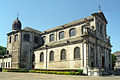 St. Begge Collegiate
 -
 The St. Begge fountain
 -
 Office du Tourisme - "Art Nouveau" house (1907)
 -
 St. Begge house (1623)
 -
 Classical house called "Maison de Chanoinesses"
 -
 Ancienne gravure du Château du Moisnil à Andenne.


See also
References
External links
Municipalities in the province of Namur, Wallonia | ||
|---|---|---|
| Dinant |  | |
| Namur | ||
| Philippeville | ||
Bold indicates cities | ||
| International | |
|---|---|
| National | |
| Geographic | |
| Other | |
This Namur Province location article is a stub. You can help Wikipedia by expanding it. |