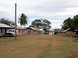
Annai, Guyana
Annai | |
|---|---|
 Annai (2014) | |
| Coordinates: 3°57′N 59°08′W / 3.950°N 59.133°W | |
| Country | |
| Region | Upper Takutu-Upper Essequibo |
| Government | |
| • Toshao | Michael George[1] |
| Population (2012)[2] | |
| • Total | 481 |
Annai is an Amerindian village[3] in the Upper Takutu-Upper Essequibo Region of Guyana.
Annai stands at an altitude of 95 metres (314 feet), at the edge of the Rupununi savannah, where the cattle trail to the Atlantic coast begins.[4] It is nestled in the foothills of the Pakaraima Mountains, and is close to the Rupununi River. Annai, considered to be the gateway to the Rupununi,[5] is approximately 15 miles north of Karanambo and is 416 km (258 mi) by road from the nation's capital, Georgetown.
Much of the population of the area are members of the Macushi people.[6] Annai is one of the northernmost Macushi Amerindian villages in the North Rupununi Savannahs. It is mainly an agriculture community living on cassava and peanut farming, and cattle ranching.[1] Electricity is provided by solar power.[6] Public services include a nursery, primary, and secondary school as well as a public health centre.[3] Annai's airstrip (NAI) allows light planes to land.[5]
Annai is home to the Rock View Ecotourism Resort, an old ranch built in the 1950s.[6] Rock View is a good base for trips to the Iwokrama International Centre for Rain Forest Conservation and Development.
Kwatamang is a satellite village of Annai that was settled in 1948, and a school was built there in 1990.[7]
References
- ^ a b "Annai Central". Ministry of Indigenous Peoples' Affairs. Retrieved 17 August 2020.
- ^ "2012 Population by Village". Statistics Guyana. Retrieved 16 August 2020.
- ^ a b "Annai Central | Ministry of Amerindian Affairs". Retrieved 2021-01-05.
- ^ "The historical Rupununi Cattle Trail". Guyana Times International. Retrieved 16 August 2020.
- ^ a b "A community in Guyana relies on indigenous knowledge in conservation". Monga Bay. Retrieved 16 August 2020.
- ^ a b c "Annai Central, a peaceful village rich in culture and hospitality". Guyana Chronicle. Retrieved 16 August 2020.
- ^ "Kwatamang | Ministry of Amerindian Affairs". Retrieved 2021-02-13.
3°57′N 59°08′W / 3.950°N 59.133°W

