Bibo, New Mexico
Appearance
Bibo, New Mexico | |
|---|---|
| Coordinates: 35°10′28″N 107°20′23″W / 35.17444°N 107.33972°W | |
| Country | United States |
| State | New Mexico |
| County | Cibola |
| Area | |
| • Total | 4.20 sq mi (10.87 km2) |
| • Land | 4.19 sq mi (10.86 km2) |
| • Water | 0.01 sq mi (0.02 km2) |
| Elevation | 6,217 ft (1,895 m) |
| Population | |
| • Total | 121 |
| • Density | 28.86/sq mi (11.14/km2) |
| Time zone | UTC-7 (Mountain (MST)) |
| • Summer (DST) | UTC-6 (MDT) |
| FIPS code | 35-07145 |
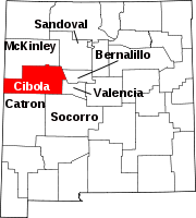
Bibo is an unincorporated community and census-designated place in Cibola County, New Mexico, United States. As of the 2010 census it had a population of 140.[3]
Bibo is located approximately 13 miles (21 km) north of Laguna on Route 279 (north of Interstate 40). The Bibo Bar and Grill is located in the community. The Nextera Energy wind project is also being developed nearby. The town was named after the Bibo brothers, who settled in the area in the 1880s. Ben Bibo operated a trading post from 1895 to 1920.[4]
Demographics
| Census | Pop. | Note | %± |
|---|---|---|---|
| 2020 | 121 | — | |
| U.S. Decennial Census[5][2] | |||
References
- ^ "ArcGIS REST Services Directory". United States Census Bureau. Retrieved October 12, 2022.
- ^ a b "Census Population API". United States Census Bureau. Retrieved Oct 12, 2022.
- ^ "Geographic Identifiers: 2010 Demographic Profile Data (G001): Bibo CDP, New Mexico". U.S. Census Bureau, American Factfinder. Archived from the original on February 12, 2020. Retrieved October 17, 2014.
- ^ Julyan, Robert (1996). The Place Names of New Mexico. University of New Mexico Press. p. 70. ISBN 0826316891.
- ^ "Census of Population and Housing". Census.gov. Retrieved June 4, 2016.


