
Black River (Wisconsin)
| Black River | |
|---|---|
.jpg) | |
| Physical characteristics | |
| Mouth | Mississippi River in La Crosse, Wisconsin |
• elevation | [1] |
| Length | 190 miles (310 km) |
| Basin features | |
| River system | Mississippi River |
Black River is a river in west-central Wisconsin and tributary of the Mississippi River. The river is approximately 190 miles (310 km) long.[2] The river begins in central Wisconsin, rising in Taylor County at 45°19′00″N 90°15′20″W / 45.31667°N 90.25556°W approximately 2.5 miles (4.0 km) west of the village of Rib Lake.[1]
The Black River flows south-southwest through Medford, Greenwood, Neillsville and Black River Falls. The Black River first mingles with the Mississippi River in Lake Onalaska in the Upper Mississippi River National Wildlife and Fish Refuge. The lower 10 miles (16 km) of the river channel have been absorbed by Lake Onalaska, an impoundment of the Mississippi River formed by Lock and Dam No. 7 at Onalaska. The river exits Lake Onalaska through a channel between French Island and the city of Onalaska and rejoins the Mississippi River at 43°49′12″N 91°15′26″W / 43.82000°N 91.25722°W,[1] northwest of La Crosse.
The Black River can be divided into two sections by the dam at Black River Falls. The upstream section averages 6.6 feet/mile gradient, while the lower section through the Driftless Area only averages 1.7 feet/mile gradient.[3] An additional distinction is that the upper section has a substrate predominantly rocky and soil that contributes tannin, while the lower section has a predominantly sandy substrate. The tannin content of the water is the source of the river's name.
The river has been used to transport lumber, coal, and petroleum products. Sawmills for the lumber contributed to the growth of Neillsville, Black River Falls, and La Crosse.[4]
The East Fork Black River rises in Wood County at 44°35′26″N 90°17′49″W / 44.59056°N 90.29694°W, southwest of Marshfield and flows 57.5 miles (92.5 km)[2] south and west into Lake Arbutus on the Black River at 44°25′50″N 90°41′41″W / 44.43056°N 90.69472°W.[5]
The Little Black River is formed by the confluence of the East and West Branches at 45°07′51″N 90°16′00″W / 45.13083°N 90.26667°W and flows into the Black River at 45°06′39″N 90°20′57″W / 45.11083°N 90.34917°W south of Medford.[6] The West Branch Little Black River rises at 45°15′59″N 90°15′07″W / 45.26639°N 90.25194°W, south of Rib Lake and less than 2 miles (3.2 km) from the source of the main branch of the Black River.[7] The East Branch Little Black River rises at 45°14′45″N 90°10′49″W / 45.24583°N 90.18028°W south of Rib Lake.[8]
Images
-
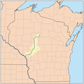 A map of the Black River watershed
 -
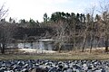 The Black River in Black River Falls


References
- ^ a b c "Black River". Geographic Names Information System. United States Geological Survey, United States Department of the Interior.
- ^ a b U.S. Geological Survey. National Hydrography Dataset high-resolution flowline data. The National Map, accessed October 5, 2012
- ^ Black River - WDNR
- ^ blackriverfalls.com - Home
- ^ "East Fork Black River". Geographic Names Information System. United States Geological Survey, United States Department of the Interior.
- ^ "Little Black River". Geographic Names Information System. United States Geological Survey, United States Department of the Interior.
- ^ "West Branch Little Black River". Geographic Names Information System. United States Geological Survey, United States Department of the Interior.
- ^ U.S. Geological Survey Geographic Names Information System: East Branch Little Black River