
Browns Creek Bike Path
| Browns Creek Bike Path | |
|---|---|
| Length | 1.6 mi (2.6 km) |
| Location | Chatsworth, Los Angeles |
| Trailheads | North: 34°16′17″N 118°35′26″W / 34.2714°N 118.5906°W South: 34°15′00″N 118°35′54″W / 34.2501°N 118.5984°W |
| Use | Active transportation, road biking, walking, dogs on leash |
| Difficulty | Easy |
| Surface | asphalt |
Browns Creek Bike Path is a Class I bike path that is “tucked away from the surrounding hustle and bustle” of the San Fernando Valley, “hugging the side” of the Browns Canyon Wash.[1]
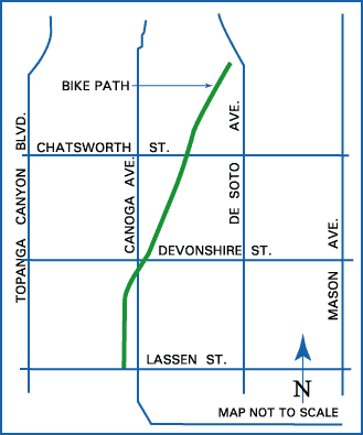
The path begins at Lassen Street, just east of Chatsworth Metrolink Station, and ends just north of Rinaldi Street near Stoney Point Park.[2]
Browns Creek (sometimes called Brown’s Creek), a tributary of the Los Angeles River, offers “splendid views of the irregularly shaped Santa Susana mountains rising to the west.”[3] One local writer observed, “What [the concrete-lined creek] lacks in scenery, it compensates for by providing the trail with an open, airy setting.”[4]
The route has been described as “very rustic” (for an urban bike path, of course).[4] The wash passes through a neighborhood with equestrian zoning and “Opposite the bike route, in the west levee, a horse trail also follows the creek.”[3] Domestic goats, roosters and ponies have also been seen along the path.[4]
At Chatsworth station, bicyclists can connect to the G Line Bikeway.[2]
The path is in close proximity to Chatsworth Park North and Chatsworth Park South (both operated by the City of Los Angeles Parks Department) and Chatsworth Nature Preserve.[3]
Both Chatsworth Parks, “excellent parks…[with] interesting hills and rock formations there, as well as pleasant shaded rest areas” are accessible from Valley Circle Road. Riders can create an approximately 6.3-mile (10.1 km) loop beginning at either end of the Browns Creek route, connecting to Valley Circle Road via either Chatsworth Street or Lassen Street.[5]
See also[edit]
References[edit]
- ^ Path, Higher (2020-10-15). "Valley Cycling: Sherman Oaks Bike Trails". The Higher Path Collective. Retrieved 2022-08-13.
- ^ a b "The Bike Blog visits Brown's Creek Bicycle Path". LADOT BIKE BLOG. 2013-12-20. Retrieved 2022-07-16.
- ^ a b c MacArthur, Loren (1985). L.A. Bike Rides: A Guide to 37 Specially Selected Bike Routes in Los Angeles County. San Francisco, Calif.: Chronicle Books. pp. 56–57. ISBN 0-87701-316-0.
- ^ a b c Mah, Russell (2011-07-04). "On This Bike Path, a Rustic Excursion Awaits". Northridge-Chatsworth, CA Patch. Retrieved 2022-07-16.
- ^ Brundige, Don; Brundige, Sharron (2007). Cycling Los Angeles (2nd ed.). San Diego, Calif.: Sunbelt Publications. pp. 159–161. ISBN 978-0-932653-81-9.
External links[edit]
- laparks.org: Brown’s Creek Trail Map
- labikepaths.com: Brown Creek - info from 2010-2020
- Bike Travel in the SFV - Chatsworth
- Los Angeles Bikeway Map (Metro.net) - HTML
- Los Angeles Bikeway Map (Metro.net) - PDF hosted on Dropbox
- "Metro Bike Map" Map of many Class I, II, and III bikeways in Los Angeles County (876kB PDF, April 2006)