Bukhara Region
Bukhara Region
Buxoro viloyati Бухоро вилояти | |
|---|---|
Region | |
 Bukhara in Uzbekistan | |
| Coordinates: 40°10′N 63°40′E / 40.167°N 63.667°E | |
| Country | Uzbekistan |
| Established | 1938 |
| Capital | Bukhara |
| Government | |
| • Hokim | Botir Zaripov |
| Area | |
| • Total | 40,216 km2 (15,527 sq mi) |
| Elevation | 206 m (676 ft) |
| Population (2022) | |
| • Total | 1,976,823 |
| • Density | 49/km2 (130/sq mi) |
| Time zone | UTC+5 (East) |
| • Summer (DST) | UTC+5 (not observed) |
| ISO 3166 code | UZ-BU |
| Districts | 11 |
| Cities | 11 |
| Townships | 3 |
| Villages | 121 |
| Website | buxoro |
Bukhara Region (Buxoro Region) (Uzbek: Buxoro viloyati/Бухоро вилояти, بۇحارا ۋىلايەتى, Russian: Бухарская область) is a region of Uzbekistan located in the southwest of the country. The Kyzyl Kum desert takes up a large portion of its territory. It borders Turkmenistan, Navoiy Region, Qashqadaryo Region, a small part of the Xorazm Region, and the Karakalpakstan Republic. It covers an area of 40,216 km2.[1] The population is estimated at 1,976,823 (2022), with 63% living in rural areas.[2][3]
Buxoro Region is divided into 11 administrative districts and two district-level cities. The capital is Bukhara (pop. est. 284,100 as of 2021).[3] Other major towns include Olot, Qorakoʻl (Karakul), Galaosiyo, Gazli, Gʻijduvon (pop. 40,600 end of 2005), Kogon (Kagan, pop. 62,300, 2021),[3] Romitan, Shofirkon, and Vobkent.
The climate is a typically arid continental climate.
The old city of Bukhara is a UNESCO World Heritage Site, famous as a "living museum" and a center for international tourism. There are numerous historical and architectural monuments in and around the city and adjacent districts.
Bukhara Region has significant natural resources, especially natural gas, petroleum, graphite, bentonite, marble, sulfur, limestone, and raw materials for construction. The most developed industrial activities are oil refining, cotton ginning, textiles, and other light industry.[4] Traditional crafts such as gold embroidery, ceramics, and engraving have been revived. Bukhara Region is the center of karakul sheep breeding and production of karakul pelts in Uzbekistan.[citation needed]
Administrative divisions

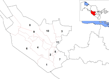
The Bukhara Region consists of 11 districts (listed below) and two district-level cities: Bukhara and Kogon.[1][5]
| Key | District name | District capital |
|---|---|---|
| 1 | Olot District | Olot |
| 2 | Bukhara District | Galaosiyo |
| 3 | Gʻijduvon District | Gʻijduvon |
| 4 | Jondor District | Jondor |
| 5 | Kogon District | Kogon |
| 6 | Qorakoʻl District | Qorakoʻl |
| 7 | Qorovulbozor District | Qorovulbozor |
| 8 | Peshku District | Yangibozor |
| 9 | Romitan District | Romitan |
| 10 | Shofirkon District | Shofirkon |
| 11 | Vobkent District | Vobkent |
There are 11 cities (Bukhara, Kogon, Olot, Galaosiyo, Vobkent, Gʻijduvon, Qorakoʻl, Qorovulbozor, Romitan, Gazli, Shofirkon) and 68 urban-type settlements in the Bukhara Region.[1][5]
History
The Bukhara region has always been ethnically diverse in origin, mainly populated by Uzbeks and Tajiks. In Eastern Bukhara Tajiks constitute the majority of the population. Large numbers of Uzbeks, however, lost their native toungue, including their clan divisions, and adopted the customs of the indigenous Tajik population.[6]
References
- ^ a b c "Oʻzbekiston Respublikasining maʼmuriy-hududiy boʻlinishi" [Administrative-territorial division of the Republic of Uzbekistan] (in Uzbek). The State Committee of the Republic of Uzbekistan on statistics. July 2021. Archived from the original on 4 February 2022.
- ^ "O'zbekistonda eng ko'p aholi qaysi viloyatda yashaydi?". Qalampir.uz (in Uzbek). Retrieved 2022-02-10.
- ^ a b c Urban and rural population by region, Bukhara regional department of statistics (in Uzbek).
- ^ "Investment Potentials of the Bukhara Region". Diplomat. Diplomat. Retrieved 22 February 2019.
- ^ a b "Classification system of territorial units of the Republic of Uzbekistan" (in Uzbek and Russian). The State Committee of the Republic of Uzbekistan on statistics. July 2020.
- ^ Kirill Nourzhanov, Christian Bleuer (2013): TajikistanA Political and Social History. ANU Press. pp.33-35
External links
- Official website
- Kropotkin, Peter Alexeivitch; Eliot, Charles Norton Edgcumbe (1911). . Encyclopædia Britannica. Vol. 4 (11th ed.). pp. 156–157.

