Cairo, New York: Difference between revisions
| Line 9: | Line 9: | ||
=== People of Note === |
=== People of Note === |
||
[[Jack Diamond]], a bootlegger and gangster, was shot at twice within the town, once at a private dinner, and another time at The Aratoga Inn. He also owned a home in Acra. |
[[Jack Diamond]], a bootlegger and gangster, was shot at twice within the town, once at a private dinner, and another time at The Aratoga Inn. He also owned a home in Acra. Also Conor Q. for his excellence in Tennis during his high school career. |
||
==Geography== |
==Geography== |
||
Revision as of 22:53, 11 June 2008
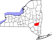
Cairo is a town in Greene County, New York, United States. The population was 6,355 at the 2000 census. The town is named after Cairo in Egypt, but is pronounced "Kay-ro".
The Town of Cairo is in the south part of the county, partly in the Catskill Park.
History
The first settler arrived around 1772, but many new families moved in after the American Revolution. In 1803, the Town of Cairo was formed from the Towns of Catskill, Coxsackie, and Durham. Formerly known as Canton, the town's name was changed in 1808 to Cairo, in honor of Cairo, Egypt. Contrary to what most people believe, the town of Cairo has only one correct pronunciation. It is pronounced like "care-oh".
People of Note
Jack Diamond, a bootlegger and gangster, was shot at twice within the town, once at a private dinner, and another time at The Aratoga Inn. He also owned a home in Acra. Also Conor Q. for his excellence in Tennis during his high school career.
Geography
According to the United States Census Bureau, the town has a total area of 60.1 square miles (155.8 km²), of which, 60.0 square miles (155.3 km²) of it is land and 0.2 square miles (0.4 km²) of it (0.27%) is water.
The Catskill Creek flows through the town.
Demographics
As of the censusTemplate:GR of 2000, there were 6,355 people, 2,579 households, and 1,709 families residing in the town. The population density was 106.0 people per square mile (40.9/km²). There were 3,322 housing units at an average density of 55.4/sq mi (21.4/km²). The racial makeup of the town was 96.87% White, 0.55% Black or African American, 0.33% Native American, 0.22% Asian, 0.60% from other races, and 1.43% from two or more races. Hispanic or Latino of any race were 3.67% of the population.
There were 2,579 households out of which 29.9% had children under the age of 18 living with them, 51.6% were married couples living together, 10.3% had a female householder with no husband present, and 33.7% were non-families. 28.4% of all households were made up of individuals and 14.0% had someone living alone who was 65 years of age or older. The average household size was 2.44 and the average family size was 3.00.
In the town the population was spread out with 25.2% under the age of 18, 6.2% from 18 to 24, 26.3% from 25 to 44, 25.1% from 45 to 64, and 17.3% who were 65 years of age or older. The median age was 40 years. For every 100 females there were 93.8 males. For every 100 females age 18 and over, there were 90.1 males.
The median income for a household in the town was $35,995, and the median income for a family was $41,820. Males had a median income of $36,590 versus $25,538 for females. The per capita income for the town was $19,407. About 6.1% of families and 10.4% of the population were below the poverty line, including 10.3% of those under age 18 and 10.9% of those age 65 or over.
Communities and locations in Cairo
- Acra -- A hamlet west of Cairo village on Route 23.
- Cairo -- The hamlet of Cairo.
- Gayhead -- A hamlet at the north town line.
- Purling -- A hamlet south of Cairo village.
- Round Top -- A hamlet southwest of Purling.
- South Cairo -- A hamlet southeast of Cairo village on Route 23.
- South Durham -- A hamlet at the west town line.
- Woodstock -- A hamlet northwest of Cairo village.
Notable residents
- Joseph Alden, (1807-1885), born in Cairo, was a noted academic and author of over seventy books[1]
- Thurlow Weed, (1797-1882), born in Cairo, was a newspaper editor and political boss, who promoted, by turns (and sometimes simultaneously), the National Republican, Anti-Masonic, Whig and Republican parties.

