Calf Island Military Reservation
Appearance
| Calf Island Military Reservation | |
|---|---|
| Part of Harbor Defenses of Boston | |
| Hull, Massachusetts | |
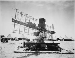
 SCR-268 radar in Casablanca, Morocco in WWII | |
| Coordinates | 42°20′23.80″N 70°53′46.17″W / 42.3399444°N 70.8961583°W |
| Type | Coastal Defense |
| Site information | |
| Owner | Massachusetts |
| Controlled by | Boston Harbor Islands National Recreation Area |
| Site history | |
| Built | 1941 |
| Built by | United States Army |
| In use | 1941-1946 |
| Battles/wars | World War II |
Calf Island Military Reservation was a World War II coastal defense site located on Calf Island in Hull, Massachusetts.
History
In 1920 there was a proposal to build a naval-type turret with two 16-inch guns on Great Brewster Island, but this was not implemented. Calf Island was also considered, but the battery was finally built (without a turret) as Fort Duvall.[1]
The Calf Island Military Reservation was built in 1941 on state land. It consisted of an early SCR-268 radar, searchlight station, and an observation post. It was returned to the state in 1946.[2]
The site today
The site today consists of the foundation of the observation tower.
See also
- Seacoast defense in the United States
- United States Army Coast Artillery Corps
- List of military installations in Massachusetts
References
- ^ Parkman, pp. 123-125
- ^ "Boston Harbor II - Harbor Defenses of Boston". American Forts Network. Retrieved 18 July 2020.
- Berhow, Mark A., Ed. (2015). American Seacoast Defenses, A Reference Guide, Third Edition. McLean, Virginia: CDSG Press. ISBN 978-0-9748167-3-9.
{{cite book}}: CS1 maint: multiple names: authors list (link) - Lewis, Emanuel Raymond (1979). Seacoast Fortifications of the United States. Annapolis: Leeward Publications. ISBN 978-0-929521-11-4.
- Parkman, Aubrey (1978). Army Engineers in New England 1775-1975. Waltham, MA: US Army Corps of Engineers, New England Division.
External links
- List of all US coastal forts and batteries at the Coast Defense Study Group, Inc. website


