
Chinari, Armenia
40°50′59″N 45°34′19″E / 40.84972°N 45.57194°E
Chinari
Չինարի | |
|---|---|
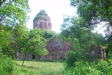
 A view of Chinari and Khoranashat Monastery | |
 Chinari  Chinari | |
| Coordinates: 40°50′59″N 45°34′19″E / 40.84972°N 45.57194°E | |
| Country | |
| Province | Tavush |
| Elevation | 750 m (2,460 ft) |
| Population | |
| • Total | 887 |
| Time zone | UTC+4 (AMT) |
| Chinari, Armenia at GEOnet Names Server | |
Chinari (Armenian: Չինարի) is a village in the Tavush Province of Armenia. Chinari lies very close to the Armenia–Azerbaijan border, and is the village closest to the abandoned Khoranashat monastery, which lies on a hill northeast of the town, only feet away from the border.
Gallery
-
 Khoranashat Monastery
 -
 Khoranashat Monastery interior
 -
 Khoranashat Monastery


References
External links
Wikimedia Commons has media related to Cultural heritage monuments in Chinari, Tavush.
Capital: Ijevan | ||
| Urban settlements |  | |
| Berd Municipality | ||
| Dilijan Municipality | ||
| Ijevan Municipality | ||
| Noyemberyan Municipality | ||
This article about a location in Tavush Province, Armenia is a stub. You can help Wikipedia by expanding it. |