Chotusice
Chotusice | |
|---|---|
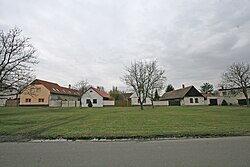
 Common in Chotusice | |
| Coordinates: 49°56′57″N 15°23′40″E / 49.94917°N 15.39444°E | |
| Country | |
| Region | Central Bohemian |
| District | Kutná Hora |
| First mentioned | 1142 |
| Area | |
| • Total | 7.01 km2 (2.71 sq mi) |
| Elevation | 224 m (735 ft) |
| Population (2022-01-01)[1] | |
| • Total | 774 |
| • Density | 110/km2 (290/sq mi) |
| Time zone | UTC+1 (CET) |
| • Summer (DST) | UTC+2 (CEST) |
| Postal codes | 285 76, 286 01 |
| Website | chotusice |
Chotusice is a municipality and village in Kutná Hora District in the Central Bohemian Region of the Czech Republic. It has about 800 inhabitants.
Administrative parts
The village of Druhanice is an administrative part of Chotusice.
History
The first written mention of Chotusice is from 1142 under the name Chotovice. In 1316, it was donated to Sedlec Abbey. Since the 2nd half of the 14th century, the name of Chotusice is used.[2]
Chotusice is known for the nearby Battle of Chotusitz, which was fought in 1742 as a part of the First Silesian War.
References
- ^ "Population of Municipalities – 1 January 2022". Czech Statistical Office. 2022-04-29.
- ^ "Historie obce" (in Czech). Obec Chotusice. Retrieved 2021-07-02.
Wikimedia Commons has media related to Chotusice.


